The ascent is hard on lungs, the descent is painful for knees,
the thin air at the altitude is unforgiving,
living out of tents in the mountains with minimal facilities is certainly
not enjoyable,the time spent on the peak or pass is hardly a few minutes.
Why do men come back to mountains again and again ?
I had just reached the snowline at 4300m, barely 200m below the Thamser Pass on 7th October 2012. The going was tough and I whispered to Naren – “Mate, We have done enough of Himalayas, guess it’s time to say goodbye”. Naren echoed along the similar lines while fully agreeing with me. Back from the successful trek to Bara Bhangal in Oct 2012, our outlook gradually changed and by beginning of 2013 we had both decided to give another try to some other pass in the High Himalaya. All the pains were forgotten and we were actively planning for our next visit – that’s the lure of the Himalaya! As usual we contacted Kaushal Desai from above14000ft who suggested Animal Pass trek which he was running for Sharada and Saravanan (Saro) and their group. Since Kaushal mentioned that Animal Pass is like a family trek in terms of difficulty level, we pushed him to give us another alternative which is more challenging. As a result it was decided that we will do Animal Pass along with Saro’s group. While they return via the same path, our group will continue ahead, cross Sara Umga Pass and reach the other side at Chota Dhara. Since horses couldn’t cross Sara Umga, we had to depend on porters which increased the cost of expedition considerably. Last minute drop out of a member from our group didn’t help us and resulted in further escalation of costs. The desire to be on the mountains and also to cross a challenging pass was so high that we were silently ignoring the insane amount of money being spent to realize our Himalayan dreams this year. Thus we had two groups doing Animal Pass together and our 2 member group continuing with Sara Umga Pass. Animal Pass group included Sharada, Saro who had accompanied us to Roopkund trek earlier, Dr Sreekumar (SK) and Dr Pradeep (both basically dentists), Venu who had accompanied me on one of my beach treks earlier and Preeti my colleague who was venturing into Himalayas and also into serious trekking for the first time. Sara Umga group included Naren and I.
Our trek started on the 3rd weekend of September 2013. We joined Saro’ group at Delhi airport and proceeded to Himachal Bhavan in a metro train. Unlike last year, we had booked tickets to Manali in HP tourism’s volvo bus. The bus service turned out to be much organized and left Delhi on time and the journey itself was much comfortable.
Day 0: Acclimatization in Manikaran
We got down 50km before Manali at Bhuntar(1080m) from where we took a local taxi to Manikaran which was the base for our trek. After an hour’s drive in the winding roads beside the River Parvati we reached Manikaran(1650m) at 8AM.

Manikaran town
Manikaran is a place of religious significance for both Hindus and Sikhs. There is a Gurudwara here and a temple complex dedicated to Rama, Shiva and Hanuman. Numerous hot water springs present here are a major attraction.

Hot sulpher water joining the cold waters of River Parvati at Manikaran
We had a full day ahead of us since the trek was starting only the next day. Morning was spent doing a small acclimatization trek to a hill adjacent to the river bank. Naren, SK, Preeti and I climbed up to the top of the steep hill and gained around 300m altitude while Pradeep could do half of the distance. Post lunch, we spent some time relaxing in the well maintained hot water sulphur spring behind the Rama temple. This was supposedly an off-season in Manikaran and less crowd in such places makes the stay a bit more enjoyable since there is so much less competition for space and resources in such a small town. We had breakfast and lunch in a small eatery run by a family and the ambiance was such that we felt being treated as guests rather than as customers.
Day 1: Manikaran to Tosh to Buddhaban
While we were having our breakfast, Kaushal arrived from Manali with his support staff which included the guide Chander, a mountaineer himself, a cook and 3 porters. We started in a couple of taxis, drove for an hour and reached Tosh village (2380m). As we approach Tosh, we can see a major Hydro electric power project under construction, which I understand would have a capacity of 2000MW! The trek started at 9.45AM in very sunny and bright conditions. The initial walk is via the Tosh village itself. Tosh has a shrine dedicated to Jamadagni Rishi. Tosh also boasts of many facilities for tourist accommodation and we could see quite a bit Israelis who apparently come to Kasol (which is called Mini-Israel), Manikaran and even up till Tosh in search of greener pastures of Marijuana.

Starting of the trek at Tosh village
At 11AM we had left the village behind and reached a stream crossing point (2500m) which was supposed to be our 1st camping site as per Kaushal. Camping just after an hour’s walk on the first day of trek didn’t look too appealing to us given that the next day’s campsite Buddhaban was just 2 hours walk from here. So we convinced Kaushal to take us to Buddhaban directly. So an oversight by Kaushal in his itinerary had given us an extra day, only time would tell if that would help us or harm us.

Kutla
The ascent is gradual and mainly through the pine forest. We reached the last village along the route called Kutla (2675m) which can serve as a potential campsite. While most of our group members were carrying walking sticks I borrowed a nice stick from the shopkeeper at Kutla. Through out the trail we could see survey stones installed by the ongoing hydro power project which suggested that this trail is going to be a proper motor-able road in near future. We reached Buddhaban (2725m) at 1PM.

Buddhaban campsite
The campsite was right on the bank of Tosh river which appeared milky white, but had too much soil particles to be consumed directly. We had to depend upon a tiny stream of freshwater that trickled down from the mountains. There was another team from Mumbai camping in Buddhaban already. Lunch was prepared and served within an hour. Kaushal’s treks are known for good and tasty food and Saro had made special request to Kaushal to get the same cook they had got during their Miyar Valley trek. But going by what we got from this new cook, we were doubtful if food is going to the highlight of this trek.
There was enough time in the day to play cricket in the makeshift pitch prepared by SK. In the evening SK, Pradeep, Preeti, Venu, Naren and I did do a small acclimatization walk for an hour, but couldn’t gain much height as the clouds closed in threatening to rain. However the night sky was very clear and the stars were out in their full glory. I was having a slight headache which indicated that I was still acclimatizing to this height.
Day 2: Buddhaban to Sharam Thach
I had good night’s sleep but was woken up at 4.45AM by the heavy rains and thunderstorms. We had noted down the 10 days’ Accuweather weather prediction for Manikaran and as per that, today it was thunderstorms. Fortunately the rain stopped in an hour and it was 9°C at 5.45AM. For most part of the trek we would be following the Tosh river which ran down from North to South in the valley and hence it took a while before the morning Sun from the East could reach our campsite. After the breakfast which consisted of Bread, Oats and Cornflakes, we started the day’s trek at 8.30AM.
The pace of rest of the group was a bit too slow for us and hence Naren and I soon moved ahead and reached a small waterfalls area (2780m) at 9AM. This waterfalls was formed by the water gushing down the slopes into Tosh river. A dog had joined us by now and it was leading us on the right path. Dog’s pace was much better than us and every now and then it would wait for us, ascertain that we are coming and would proceed ahead. We continued the ascent through the forests and by 9.30AM we were at 2885m from where we could see a few tents of the labourers from hydroelectric project pitched on the right bank of Tosh river. At 10AM we reached Shiyadi Thach (3000m) campsite. This place had a wide opening in the canopy and we settled down on a huge boulder beside the cultivated Marijuana field and waited for the rest of the group to catch up. While we were using hats to protect ourselves from the Sun, the dog was lying down beside us in our shade.

Shiyadi Thach
By 10.30AM the entire group was at Shiyadi Thach and we started back on trail. The next stretch involved a few ascents and descents in the forest and we crossed a stream and reached 3215m at 11.30AM. Next we walked past a few trees which looked like fig trees and they stood out in the company of pine trees. Here the dog was joined by a similar looking bitch and they continued the march together. At 12.50PM we crossed a stream over a stone bridge laid out on a pair of log woods and reached Sharam Thach (3345m) campsite at 1PM. We ate the packed lunch consisting of an Aloo Parata.

Sharam Thach campsite
The porters and horses had reached just before us and had only pitched kitchen tent and a couple of tents when the sleet shower started. Soon it turned into a heavy rain and we ran around and got all the bags, sleeping bags and mats into the tents before settling down in our tent. As per weather report, thunder storms were predicted for Manikaran today and we were always walking with good pace to escape any showers. We had managed to do that, but rest of the group was caught up in the rains and by the time the last of the group members arrived at Sharam Thach, it was 3.15PM. Most of them had arrived completely wet. There was no respite from the rains and it continued to pour down till 8PM in the night. We had some minor irritants like water condensing inside the tent as well as coming into the tent via window opening due to winds.
The day ended pretty early and the night was cold. The old sleeping bags without the chord to tighten the hood didn’t help in retaining the body heat.
Day 3: Sharam Thach to Shamshi Thach
I got up at 5.30AM and the temperature was 5°C. Yesterday’s rain had completely washed off the clouds and the sky was clear. The weather was perfect to try out some breathing exercises. We started the day’s trek at 8.30AM. Today we were out of the tree line and were supposed to walk on the left bank of River Tosh and cross multiple ridges on our way to Shamshi Thach.
Though Accuweather predicted sunny and clear weather for next 3 days, Preeti, based on her yesterday’s ordeal decided to join me and Naren in today’s trek. Unfortunately for her, we soon lost our way and couldn’t locate the trail. There was a huge mountain running alongside the river on our left with multiple ridges and the river itself was to the right of us. We could see a fairly big ridge at a distance running down and tapering towards the river. We knew if we reach that ridge, further progress of the trail will be visible, but Naren and I differed on how to approach that ridge. While I preferred to not lose height and walk along the mountain face, Naren preferred to descend and walk on the river bed. Finally we decided to stick to the middle ground and ended up being neither here nor there. But this had it’s own share of thrills especially for Preeti as we negotiated stretches of boulders. Finally at 10.30AM after a steep climb we finally reached the ridge (3600m) and caught up with the trail as well. Unfortunately the entire team followed us even when we signaled them to maintain height and not to loose the trail. So everyone including Kaushal had to go through the effort of the steep climb to re-join the trail on the ridge.
The next stretch was mostly easy without any major descent or ascent. At 11.30AM two snow capped peaks became visible, with one of them looking like a tooth of a carnivore!

Tiger tooth! as seen enroute Shamshi Thach

An unnamed peak as seen enroute Shamshi Thach
By 12PM were were able to see the campsite but a bunch of streams separated us and the campsite. Nowhere we could find a suitable place to cross with our shoes on and followed the stream up on it’s course to see if it offered any easy crossover points. But it was already midday and the streams were running full and we had to retreat and cross the streams with barefoot. We finally reached the Shamshi Thach (3680m) campsite at 12.20PM.

Shamshi Thach campsite
The settings of Shamsi campsite was spectacular to say the least. To the East, the River Tosh flowed in all its majesty. Even though the width of the river was fairly small, the sandy shore was unusually wide for a mountain river. Behind the river was a pyramid shaped peak. To the West of the campsite, a few streams dropped down the rocks to form waterfalls and a multitude of streams that eventually joined Tosh. Towards North, at the end of Tosh valley, we could see the Sara Umga Pass. While SK, Venu, Preeti and I were exploring the sandy shores of Tosh river, I could see Sharada and Saro walking up the streams towards the waterfalls to figure out a crossover point. Eventually I had to go and show them where to cross the streams.

Sara Umga Pass as seen from Shamshi Thach
There was an Italian climbing team of 3 men who were already camping at Shamshi. Kaushal was providing logistical support for them too. They had a full fledged kitchen and a much experienced cook. We had Pakodas followed by rice bath for lunch. Naren, Preeti and I did a small evening walk too. By 4PM all the streams that were running down from the mountain become muddy and non-potable. However there was one tiny stream which remained good throughout the day which became our source of water in this camp. By 4.30PM itself, the meadow lost the last direct rays of Sun after which it started becoming pretty cold.
Day 4: Animal Pass
The temperature at 6.15AM was 4°C. The breakfast was good for the first time, thanks to the cook Kishen from the Italian camp. The plan for the day was to reach Animal Pass and be back at the camp by evening. Pradeep hadn’t acclimatized and hence he decided to skip the trek. Saro too had mild altitude effect and moreover was suffering from stomach upset. So he also decided to skip the Pass. Sharada decided to stay with Saro. Thus the group attempting the Animal Pass had Naren, SK, Venu, Preeti and I. Kaushal, Chander and Bhagwan Das, the guide from the Italian camp were leading us. We started at around 8AM. The trial was fully uphill and we were making steady progress and reached 3775m at 8.30AM. By this time, Naren who was suffering from altitude sickness was lagging behind with a lone porter with him. In fact Naren had fixed a turn around time of 12PM and do as much as possible by that time and return back.

Extreme left – Devachan, Snow peak around center – Papsura, Extreme right – Dharamsura or White Sail
By 9AM we had reached 3915m and now the view to the Tosh Glacier was slowly opening up. By now we had lost Naren completely at the back. We were now able to see three peaks in the Sara Umga range clearly. Devachan peak (6200m), Papsura Peak (6451m) and Dharamsura peak (6446m) also called White sail were all visible. Harish Kapadia in his book “Across Peaks & Passes in Himachal Pradesh” writes: “The legend has it that the two mountains gain ascendency over each other according to whether the forces of evil (Pap) or those of good (Dharm) happen to prevail over the world at that time. So now we know!”

Tosh river
As is typical in such climbs, we were reaching the top of a ridge only to see the next higher ridge in our path. At 9.30AM we reached 4000m. At 10AM were were at 4100m from where the vegetation became less and less and it was mostly boulders on our way. We reached 4200m at 10.35AM and 4300m at 11.10AM from where we could see a bearded vulture or Lammergeier in flight.

Tosh Glacier
The ascent continued over rocks and rubble and we reached a lake (4340m) at 11.25AM.
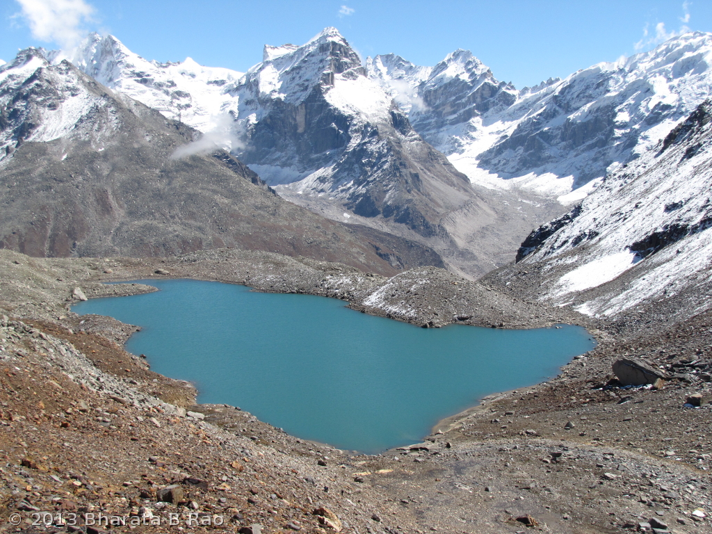
The lake near Animal Pass
On the other side of the lake was the Animal Pass. The blue coloured lake was very beautiful and the 360° view around the lake was breathtaking. While Venu preferred to stay put at the lake, the rest of us continued towards the Pass. First we had to reach the other end of the fairly big lake by negotiating the boulders. Next it was a steep climb over loose soil and small rocks. Kaushal and Bhagwan were leading and it was difficult to climb in their pace. Towards the end, I lost them both in the front and also Preeti and SK being led by Chander at the back. I reached Animal Pass (4500m) at 12.40PM.

The Animal Pass as seen from the lake below it
While Kaushal and Bhagwan proceeded further up towards the right of the Pass to check out the views from there, I was satisfied to catch a glimpse of Deo Tibba (6001m) from Animal Pass and remained there.

Deo Tibba as seen from Animal Pass
To the left of the Animal Pass, raises a rocky peak called Ali Ratni peak (5490m) as per Kaushal.

Ali Ratni Tibba in the background of Animal Pass
After a few minutes Preeti with her hand firmly in the able hands of the guide Chander arrived followed by SK. Preeti didn’t let loose of guide’s hand till she reached back the campsite safely! Another member who reached the Pass without much fuss was our dog which even stepped onto the snow and rolled over it to cool itself down.
We started back at 1.40PM and took the left bank of the lake while we had ascended on the right bank. When we reached the end of the lake where we had started out from, we had done one circumambulation (parikrama) of the lake! We joined Venu near the lake at 2.30PM. For the descent we took a slightly different path and did a steep descent of a huge grassy mountain face to reach the Tosh river bed instead of taking the original route which had many ridges to negotiate. The clouds were coming pretty down sometimes and walking in the midst of the clouds was some experience.

The final descent from Animal Pass
Naren had returned back with the porter after having reached 4200m. He hadn’t acclimatized fully yet and Kaushal indicated that it will be risky to ask him cross Sara Umga. Naren and I deliberated over our next course of action. While Naren said he is willing to return back the next day with Saro’s team, I suggested that he could try coming till next campsite Kuta Thach and remain there while I try to reach Sara Umga and come back. So crossing Sara Umga plan was thus dropped.
Day 5: Shamshi Thach to Kuta Thach
Saro’s team’s mission was accomplished and they were ready to return today. They had decided to cross Sharam and reach Buddhaban in a day and reach Tosh/Manikaran/Manali on the next day itself. In the morning Naren appeared quite OK and he said he can make it to Kuta Thach but at his own slow pace.
At 8.30AM we bid goodbye to Saro’s team members who were on their way back. At 9.45AM Naren and I along with Kaushal, Chander and two porters started towards Kuta Thach. The Mumbai team had arrived at Shamshi yesterday evening and were also moving up to Kuta today. The trail had an initial climb just after Shamshi. The Mumbai group members who were carrying their day packs themselves were struggling on this stretch and so was Naren. However Naren was able to overtake the Mumbai group and make progress.

The full glory of Tosh glacier

Ice ends and the water begins – The origin of Tosh river
At around 11.30AM we were very close to Tosh glacier and we could see the snout of the glacier from a short distance. At 12.30PM we touched 4000m and from here it was mostly a walk on the level ground without much of an ascent. At 1.15PM we reached 4045m where we finished our packed lunch which consisted of 2 chapatis. At 1.50PM we walked past a possible campsite which had no water source at this time of the year.
At 2.10PM, we could see the campsite and Kaushal went ahead while I waited for Naren to catch up. At 2.30PM we crossed multiple streams which included a major one which needed assistance from the guide for crossing. We reached the Kuta Thach campsite (4065m) at 2.30PM. What could be attained in less than 2hours was done in 4.45hours since Naren’s was struggling a bit.

Kuta Thach campsite
Kuta Thach wasn’t as pleasant a campsite as Shamshi. It was in the middle of a rubble and looked like a place unfit for human habitation. A tiny stream flowed beside of our campsite which now consisted of 2 dome tents and 1 pyramid shaped tent for porters. The stream water had to be sieve-filtered since it had too many organic floating matter. The campsite was right beside the glacier and a 50m descent towards our right would have landed us straight on the moraines of the glacier.
Minimal kitchen supplies were being carried and we had to be content with half-cooked MTR pulao. Naren wasn’t doing good and I was hoping a night’s rest would serve him good. Naren had by now developed diarrhea for which he took some medicines from a doctor who was present with the Mumbai group.
Clouds started closing in around the campsite by 3.30PM. Maggie noodles was served as snacks and Rice and Sambhar were cooked for dinner.
Day 6: Kuta Thach to Shamshi Thach
The noise inside the tent when it rains doesn’t usually bring in a good feeling. This noise started during the later half of the night and continued well into the morning. We had planned to start the hike to Sara Umga pretty early in the day at 7.30AM since it would take at least 8-10 hours from Kuta to reach the Pass and come back. Any hopes of doing Sara Umga today were all washed down when it started snowing and the visibility was reduced to a few meters. It was as if the entire Kuta camp was engulfed in the clouds. The Mumbai group started to descend even while it was raining. Naren’s diarrhea had turned into stomach pain by now and the doctor suggested him to take antacids before he left.

Snow at Kuta Thach
We had an extra day and we could have stayed at Kuta today to see if the weather clears tomorrow. But Naren’s condition needed immediate descent and his body had failed to acclimatize. As soon as the weather cleared, we started the descent at 11.30PM. The descent back to Shamshi turned out to be very long since Naren was finding it difficult to walk even 10 steps continuously without a break. Kaushal and I would walk ahead, then wait for Chander and Naren to catchup. In the middle of the descent, after looking at Naren’s condition, I decided to stick with him. His progress was painfully slow while he was having regular painful stomach spasms. With continuous pushing and encouragement, I managed to get Naren to the campsite at 4PM. Naren’s condition was very similar to what he had undergone last year when crossing Kalihani Pass.
We had a good lunch, thanks to the cook Kishen at the Italian camp. It started raining at 5.15PM.
Day 7. Rest day at Shamshi Thach
Since we had enough days left and since Naren was yet to recover fully, we decided to spend a day at Shamshi. I got up leisurely at 6.30AM to find the sky mostly clear. The Sara Umga pass visible at a distance was slowly getting covered by clouds and became completely invisible by 8AM. So even if we had stayed back at Kuta yesterday, in all probability we couldn’t have made it to the Pass given the weather.
We had planned for a minor hike in the surrounding hills, but I could only do a bit of ascent to the waterfalls area. This waterfalls was the source of all the streams near the Shamshi campsite. The weather turned dull and was pretty fickle. It would be sunny one moment, only to become cloudy and drizzly the next moment. All we could do was to sit inside our tent and go to kitchen tent at regular intervals for breakfast, lunch and dinner.

The train of cloud as seen from Shamshi
One has to spend an idle day in the mountains to really understand how boring it can be in the mountains with nothing to do for the day! Here is a quote from Eric Shipton’s Upon that Mountain that best describes our mood on this day:
I doubt if anyone would claim to enjoy life at high altitudes — enjoy,
that is, in the ordinary sense of the word.
There is a certain grim satisfaction to be derived from struggling
upwards, however slowly; but the bulk of one’s time is necessarily spent
in the extreme squalor of a high camp, when even this solace is
lacking…… except for the briefest moments, during which one is not
usually in the mood for aesthetic enjoyment, there is nothing to look
at but the bleak confusion inside the tent and the scaly, bearded
countenance of one’s companion — fortunately the noise of the wind
usually drowns out his stuffy breathing; worst of all is the feeling of
complete helplessness and inability to deal with any emergency that
might arise. I used to try to console myself with the thought that a year
ago I would have been thrilled by the very idea of taking part in
our present adventure, a prospect that had been seemed like
an impossible dream; but altitude has the same effect on the
mind as upon the body, one’s intellect becomes dull and unresponsive,
and my only desire was to finish the wretched job and to get down
to a more reasonable clime.
Day 8. Shamshi Thach to Tosh to Manikaran
The morning was extremely cold and the surroundings had turned slightly whitish with bits of snow and ice all around. The first thing I told Naren in the morning was “Naren, I think …”, the rest was filled in by Naren himself when he said “‘… we should attempt to reach Manikaran today”.
So we started at 8.30AM and made some good progress. While I was accompanying Kaushal, Chander was coming with Naren. As we descended more, Naren’s condition improved dramatically. We reached Sharam Thach at 10AM, Shiyadi Thach at 11.50AM, Buddhaban at 12.45PM, Kulta at 1.20PM and Tosh at 2.15PM. I met the Kutla’s shopkeeper from whom I had borrowed the walking stick and promptly returned it to him. He was impressed that this walking stick had reached Animal Pass!
From Tosh, we took a taxi and come to Manikaran at 3.15PM. The first thing we did in Manikaran was to take a dip in the hot water springs. The sulphur springs had such a soothing effect that we came up from the Kund with no pain in the body whatsoever!
Apparently the Goddess scorned our softness. She also rammed home
the message that success does not depend on money. This was my
most costly expedition and it proved to be the least fulfilling.
My financial graph showed clearly that the tighter the funds,
the more memorable the outcome. Nothing in Nanda’s domain is
won easily.
Bill Aitken
The Nandadevi Affair
And I couldn’t agree more with Bill – nothing in Himalaya’s domain comes easily.


 Posted by Bharata


