Packing for trek, bus travel, walking under the forest cover, crossing the tree line, passing by shola forest ranges, crossing running streams, negotiating the unending ridgeline in the grasslands under scorching Sun, the high of reaching the peak – All these motions were mostly forgotten and felt like things from the previous life as other interestskept me busy during the last five years. My last trek was to Devkara falls was way back in 2015.
Austin, with whom I have done a few Shiradi trekswas camping in his Sakaleshpur Coffee estate for sometime and we thought what better way to catch up after a long time than spending time together in a Western Ghats trek. Thus it was decided to trek to Ballalarayana Durga in the Charmadi range.
Naren and I started from Bangalore in KSRTC Rajahamsa bus which dropped us at Sakaleshpura at 3 in the morning. Austin had arranged our pick up and we reached his estate house and completed our morning duties. The day’s plan was to trek to Ballayarayana Durga from Sunkasale. We were out on the road before 6AM in Austin’s cousin Denver’s car. It was close to 2hrs drive via picturesque winding roads with a stop in Kottigehara for breakfast. Nirdose, Idli and Pooris were on the menu.
We reached Sunkasale by 8AM where we met J W Lobo, Austin’s distant relative. J W Lobo has retired after serving Govt of India in ICCR, MEA and has done extensive study about the region around Ballayaranana Durga and its history. He had done complete arrangement of our trek including getting forest permission, arranging for guide and working out our itinerary. First he gave us a brief account of the history of Sunkasale through which the forgotten High Road or the “Heddari’‘ that was used more than 1000 years back to travel from Mangaluru to Chikmagaluru passes. It was in 12th AD that Veera Ballalaraya I of the Hoysala dynasty constructed a toll gate (Sunkasale) on the “Heddari”. He also built the fort on Durgadahalli Hill which came to be known as Ballalarayana Durga. (Source: Book Ballarayana Durga by J W Lobo).
Anil Gowda, an officially trained trek guide from the forest department joined us here and together we went first to visit Sri Kalabhairaveshwara temple at Balige. This temple was built by the Hoysala Raya by the side of Heddari. The temple is at an elevated serene location, and is accompanied by a tank nearby. Daily Pooja is performed at this temple, but the Garbhagruha wasn’t open when we were there, but we could take a parikrama of the temple.
Sri Kalabhairaveshwara temple, Balige
At 9AM we were at 1150m when we hit the trail.
Start of the trail
J W Lobo accompanied us till the view point from where Kadtikal Ghat and Rani Jari peak are visible. As per Mr. Lobo’s book, Kadtikal Ghat remains as historical testimony to the sufferings of thousands of Mangaluru Catholics who were captured, enslaved and taken as prisoners by Tipu. This Ghat and the Heddari remained as the main route from Coast to regions beyond Ghats until Charmadi Ghat road was formed in mid 19th century. A vertical drop point, popularly known as Tipu drop is present at this point. As per natives, this was where many people were dropped down and it got its name from the perpetrator. Mr. Lobo explained to us the history of the place and took leave while we continued towards the fort with our guide.
Kadtikal Ghat (Photo courtesy: Naren)
The initial climb is through a semi-dense forest and we were out of forest cover at 10AM (1330m). It is just a 15min climb from here to the top of the hill (1410m) through which the fort wall runs.
Ballala Rayana Durga Fort
Our next destination was to reach one of the entrances of the fort. Thus after a 30min short walk we reached the fort entrance at 10.45AM (1330m).
After a short break here, we restarted the trek at 11AM with the aim of reaching Bandaje waterfalls. Our guide set a steady pace and all of us followed him promptly without much breaks in between. Both the shoe soles of my long unused hiking boots had given away in Bangalore itself the previous night and I had to hurriedly buy a pair of slippers from the Majestic bus stand area. Hiking in this new footwear, which was unsuitable for this terrain did give me some problems but harsh Sun was a bigger concern for all of us. There was hardly any shade and we were completely exposed to Sun. However as usual with all our treks, we were carrying enough oranges which gave us much needed energy throughout.
We were mostly walking along the border of Chikmagalur and Dakshina Kannada districts. The fireline created by the forest department to prevent the spreading of fire along the district border was prominently visible. We could also see a few hills fully burnt from forest fires on the Chikmagalur side.
Fire line along the border of Chikmagalur and DK districts
At 12PM we had reached an altitude of 1300m and from here the descent started. While we did pretty well with the ascent till now, descent was pretty painful for me. We reached the top of Bandaje falls (1040m) at 12.30PM. There was a good amount of water in the falls in this season also (mid February), but the full grandeur of the falls isn’t visible from the top. A bit of adventure in reaching the edge of the rocks to have a better view could have helped. We have usually done such things in the past, but refrained from such avoidable risks this time 🙂
Bandaje falls starts here
We had reached the falls quite early in the day and had enough time to relax and enjoy our MTR ready to eat lunch at the falls. After an hour’s break at the falls, we started back at 1.30PM and reached the base at 4PM.
MTR RTE lunch (Photo courtesy: Naren)
J W Lobo had arranged for early dinner at Durgadalli Home Stay. Sanjay Kumar of the Guest House had prepared a good spread that started with local delicacy called Tambuli and ended with Jamun for desert. However I skipped this good dinner as I wasn’t feeling hungry at all after our MTR ready to eat lunch.
Next we visited J W Lobo’s estate house, where we had interesting discussions about various topics from history. We thanked Mr. Lobo for arranging this perfect trek, took leave of him and drove back to Austin’s place in Sakaleshpura.
Devkara is a small village present in the border area of Yellapura and Karwar. Now it is mostly an abandoned village thanks to relocation after Kadra and Kodasalli dam projects. But this village hides a natural treasure, a spectacular waterfalls which the locals call Devkara Vajra. Devkara stream falling from approximately 200-300m height near Devkara village forms this waterfalls. Devkara stream eventually joins the Kali river. This falls can be approached from the Kadra side as well as from Yellapura side. Here is my story of multiple attempts to reach this waterfalls from Yellapura side.
1st attempt
In May 2014, my brother-in-law and I rode a bike from Sonda, Sirsi, traveled to Yellapura and then to ಈರಾಪುರ village. We hardly had any information about the falls then and unfortunately we couldn’t reach anywhere near the waterfalls. All we could get was this distant view of the Kodasalli back waters.
Kodasalli backwaters
However we did establish a local contact who agreed to take us to the falls next time.
2nd attempt
I was at Sonda, Sirsi in the first week of Oct 2014 and took that opportunity to revisit Devkara falls. This time we reached the local contact’s place at ಈರಾಪುರ village and started trekking in the forest route at 10AM. Along with the guide, our local contact was accompanying us with his school going son. The guide took us on a circuitous route and we first reached very close to Kodasalli reservoir at 11.30AM.
Kodasalli dam
We were walking on a mountain range overlooking a valley in which Kali river was flowing. On the opposite side of the river was another range where the waterfalls was present. After walking through the forest for an hour, we finally emerged out on top of the mountain range at 12.30PM. This place was called ಹಬ್ಬು ಕೋಟೆ/ಕಟ್ಟೆ and it provided good view of the distant waterfalls. From that far off distance the falls looked so big and we wondered how gigantic it would it appear from the base. Unfortunately we hadn’t planned for a day long trek and we were just carrying a few raw cucumbers and butter milk which we completely finished at ಹಬ್ಬು ಕೋಟೆ.
Distant view of Devkara falls
Since reaching the base of the falls from here was out of question, our guide offered us to take us around a bit and show us a few places of interest. Thus we proceeded ahead on the same mountain range and reached a place called ದೇವಿಮನೆ. This is some sacred place in the hills where the villagers would come and offer prayers once in a year in November. From this place we did venture ahead a bit to get a clear view of Kadra reservoir. Instead of returning back via the same route, our guide suggested that we could do a full circle by getting down to Devkara village and then climb up ಬೆಂಡೆಘಟ್ಟ to reach back ಈರಾಪುರ village. We didn’t really know how much time and effort that would take, but just agreed.
After a steep descent we were at Devkara village at 3PM. The village is mostly deserted with a few houses still remaining. There is a Ramalingeshwara temple in the village where Pooja is done once a week. A priest comes from a far off distance every Monday for this purpose.
Devkara village
Ramalingeshwara temple, Devkara
We were now walking beside the Kali river. A trail exists from Devakara till ಬೆಂಡೆಘಟ್ಟ, but were dead tired since we hardly had any solid food since morning. The journey seemed endless and we finally reached the foothills of ಬೆಂಡೆಘಟ್ಟ at 4.15PM. The climb up is abruptly steep and it took quite a bit of effort and time to reach the top at around 5.30PM. Our enterprising guide could find some tender coconuts in an abandoned house and that came as a big relief to us. But the relief was short lived as it started raining. By the time we reached our local contact’s house, we were completely drenched. We consumed the food that we we had planned to have for lunch here and started back on bike towards Sonda at around 6.30PM. Next 60km drive through the winding forest roads was mostly treacherous with non-stop hard rain. Our adventure finally ended when we reached home at 9PM.
3rd attempt
Though we had seen the waterfalls, that was hardly satisfying since we hadn’t been able to reach the base of the falls. So last week we made another attempt to reach the falls. This time I took Naren with me to my in-laws place. My brother-in-law found a person from Devkara village itself who had relocated to Sonda. He was ready to guide us and we thought our 3rd attempt should be a success since the guide was born and brought up in Devkara village and he should be able to guide us to the base of the falls.
4 of us started in 2 bikes at 8AM from Sonda and reached ಈರಾಪುರ village at 10AM. Thanks to two wheelers, we were able to cover some trail distance too on bike. At 10.30AM we were at the starting point of ಬೆಂಡೆಘಟ್ಟ (470m) from where we had to descend. At 11AM we reached 130m and touched a flowing stream locally called ಈರಾಪುರ stream which eventually becomes Kali river. We walked towards Devkara village alongside the stream and at one point, the falls becomes visible towards our left.
At 11.45AM, we reached 70m and crossed the stream which was utmost knee deep. Next we had to cross another stream that flows from Devkara falls and joins the stream that we just crossed. This stream was flowing with good speed and we had to find a suitable place to crossover. Thanks to our guide, we did find a reasonably safe place to cross the stream where the water was thigh deep at places. We were able to cross it with reasonable ease using sticks for support. We were now at the periphery of Devkara village and were walking along a few abandoned houses and paddy fields.
Next it was some hide and seek with the waterfalls as it is located in such a place covered with dense forest towards its approach that it is not visible at every point on the approach path. There was no well defined path to the falls, but we had to make one by clearing the forest growth and following the general direction of the waterfalls.
Devkara falls
At 1PM we reached a rocky clearance from where the falls was visible fairly clearly. Based on our last year’s experience, we weren’t taking chances with food and hence were carrying sufficient amount of Pulao, home grown cucumbers, butter milk and ಚಕ್ಕುಲಿ. We finished lunch on these rocks. We had still not reached the exact base of the falls and hence ventured into the forests a bit more to check if better view of the falls could be had. At 2PM we reached another rocky clearance from where we had a decent view of the falls. We decided to end the quest here since the path ahead to the ultimate base of the falls was difficult and it was already well past midday.
On the way back, it took two hours for us to reach ಬೆಂಡೆಘಟ್ಟ base and after an hour we were back at ಈರಾಪುರ village. Thus on the third attempt, we finally had satisfying views of Devkara falls! It was not just about the falls, but this also turned out to be good trek worth remembering after my previous trek in the same area.
Any day I would prefer bone-chilling cold or even rain to scorching sun during my treks. Apart from Ombattu Gudda trek and beach treks, I haven’t done treks post December in any trek season. So I was a bit weary when Pradeep Hegde invited me to join his group which was attempting to trek from Magod Falls to Shivaganga Falls during 1st weekend of April. I have visited both of these falls but the challenge in this trek was to follow and walk beside the river between these two falls. But the invitation was hard to resist as I would be venturing into Karnataka Western Ghats region in Uttara Kannada District for the first time. Moreover, I was just a participant in this trek as opposed to being an organizer in most of my treks which sometimes is easy.
Though I had booked the bus ticket till Yellapura, I got down at Sonda for a quick visit to my in-laws place, had a good breakfast and got myself dropped at Magod falls (around 35km from Sonda) in bike by my brother-in-law. While I waited at Magod for rest of the group to arrive, Pradeep asked to me instead come over to Jenukallu Gudda, a view point overlooking a valley and which is around 4km from Magod. Apparently a local had advised Pradeep to attempt the initial descent from Jenukallu Gudda since descending down the Magod falls will be difficult and will need ropes. Though our group was equipped with ropes, we decided to start with an easy descent. The group had 12 members: Pradeep, his neighbor Satheesh, Avinash, Venkataraghavan, Vinayak, Nagarjun, Bharath, Ravi, Naveen, Sriharsha, Abhishek and I. The original plan was to reach Bedti river at Magod, follow it downstream till it joins Shalmala River and continue following Shalmala river upstream until it reaches Shivaganga falls.
View from Jenukallu Gudda
We started the descent from Jenukallu Gudda (470m) at 10.45AM. The descent was mostly steep with dry leaves on the forest floor making the descent a bit more challenging. We lost altitude quickly and hit a jeep tack (80m) at 11.30AM. We took right deviation into the jeep track and started walking with the hope that we will reach the confluence of Bedti and Shalmala rivers along the way. After a few hundred meters into the track we could see a dried up river bed towards our left and we continued the walk for an hour or so under direct sun before reaching a Siddimane (A house belonging to Siddi tribe) at a village called Kelase. To our surprise, we learnt from Siddis that we are way ahead of the confluence point and are in fact walking in the opposite direction! At Siddimane, we took a break to prepare lemon juice since fresh water was available here.
Dried up river bed near Kelase village
At around 1.15PM, we reversed our direction, continued to make progress on the jeep track and reached another Siddimane at 2PM. We had a good lunch that included “Avalakki oggarane” from Pradeep’s house and “Masala Majjige” (butter milk) mixed with lemon grass. Post lunch, a Siddi boy briefly accompanied us till the river and after which we were on our own walking upstream along Shalmala river (after the confluence with Bedti) which had a good amount of water in it considering that it was summer. We were now on the right bank of the river and the path mostly consisted of boulders. The heat was a bit too much for me and the walk was made further difficult by the blisters I had all over the feet.
We went past a few Siddis who were fishing and finally reached the confluence (125m) of Bedti and Shalmala at 4.45PM. While the confluence point had a bit of depth and hence calm waters, the Shalmala side had gushing water and was rocky.
The confluence of Bedti and Shalmala rivers
Many of us spent some time cooling ourselves in Shalmala while most of the group had an extended river time at the confluence point. Swimming and breath-holding skills were at display: while Satheesh excelled in swimming and managed to crossover to the other bank, Vinayak could hold breath under water for more than 2min!
Our camping site was on the river bed at the confluence point which already had arrangements for stove (made of stones), all we needed was to get some dry wood which was available in plenty. Boiled rice Ganji with pickle, curd and butter milk was on the menu. Ganji was so very filling and was a bit unusual for me since we usually stick to ready-to-eat stuff to keep the logistics simple in our treks. The night was cloudy and warm and sleeping inside the sleeping bag wasn’t an option for many. There was even a light drizzle past midnight.
On Sunday morning, we got up fairly early and wanted to end the trek before noon to avoid the harsh summer sun. The combination of pickle and freshly obtained honey (given to us in the morning by Siddis from their night’s catch) gave a distinct flavour to yesterday’s Ganji and I could see Ganji was more in demand than the freshly prepared maggi noodles! We started upstream alongside Shalmala river at 8AM after a round of lemon tea with honey.
Shalmala river side was very rocky and we were mostly walking over huge boulders. We had to cross over to the opposite bank multiple times whenever forward progress on one bank was difficult or impossible. With the amount of water in the river in April, we mostly could negotiate the river without much difficulty and I am sure the challenges on this trail will be totally different if the water level was high. But we were facing a different challenge and that was the dry heat. The rate at which I was loosing water via sweat seemed to be more than the intake rate. Given that we were walking beside a river, there was never shortage of water fortunately.
River Shalmala
At 10.30AM when I was feeling a bit down, we had a lemon juice break. I must have taken close to a litre and it really helped to get my energy levels back. Next we climbed over to a small hill only to realize that it was more difficult than a small jump over the rock that we were planning to originally avoid. Thus we had to backtrack and make progress over the boulders itself. The quest for the end (Shivaganga falls) continued and we kept making progress in the hot sun. I even reached a stage where I felt just drinking loads of water wasn’t helping me and had to resort to Glucose which Pradeep was carrying. I can’t remember when I had taken Glucose on a trek, must have been in the last decade, but such was the harshness of this trek for me.
Shivaganga falls
Finally we reached the base of Shivaganga falls (270m) at 1PM where we consumed chapattis for lunch with Chatni pudi, jam and honey. Next it was a steep climb to reach the view point of the waterfalls (465m) from where we had hired a jeep. Thus ended one of the most difficult treks I have done in recent times. Though the trail distance and the terrain was manageable, the summer sun brought out a whole new challenge to the trek. I have done treks earlier in other extreme conditions like winter trek at -20°C in thigh deep snow, altitudes upwards of 5000m etc, but this summer trek in seemingly easy terrain turned to be a trek to remember as far as endurance is concerned.
Map of the route we took is here, courtesy Vinayak.
My last tryst with Karnataka Western Ghats was in 2011 when we trekked to Deepadakallu and Jenukallu peaks from Maragunda. A couple of disturbing incidents involving trekkers getting lost/killed in the forests dissuaded us from exploring any new routes. Having completed most of the exciting trails in Charmadi and Shiradi range, we were mostly content doing an yearly Himalayan trek. But after a partially successful Himalayan trek to Saraumga Pass, we were longing to get back to the forest trails of Western Ghats. There are only a few options if you want to trek in Karnataka Western Ghats with proper permission from Forest Department – Kudremukha and Kumara Parvatha come to my mind. Since I had done Kumara Parvatha already twice, we decided to do the famous Kudremukha peak.
Kudremukha peak seen on the left side of Gaumukha peak
Kudremukha has become synonymous to trekking in Karnataka and it is a favorite beginner’s destination. Though we knew it would be crowded during the weekends, we decided to go ahead since it was one of the few officially permitted trekking trails. The trek was planned for the last weekend of November. The group comprised of 7 trekkers: Naren, Austin and his friend Prashanth, Preeti, Pradeep and I. The group had two beginners: Preeti for whom this was her first Western Ghats trek though she had done Animal Pass Himalayan trek earlier this year and Pradeep who was an absolute fresher. I contacted Sathish from Mullodi village at Kudremukha base who provides lodging and guide services to the trek. Logistics-wise this is an easy trek since everything including permission, food, guide and accommodation was being arranged by Sathish.
We boarded the Horanadu bus on Friday night from Bangalore. What to expect in next 2 days was evident when we got a a bunch of over-excited trekkers in the bus for company who hardly allowed us sleep. We reached Kalasa at 7AM where Austin and Prashanth joined us. Next it was again a short bus journey to reach Balagallu village. From there it was an uphill climb through the winding roads in a jeep and we reached Mullodi village at 9AM. Mullodi village (1180m) is situated at the base of Kudremukh mountain range. Our accommodation was arranged in Sathish’s house which would be hosting 15 other trekkers we were told earlier. But we were surprised to find out that there will be at least 50 more trekkers camping at this house for the night. Fortunately most of the people had already started the day’s hike, however there were still enough people to form a queue at the only one bathroom that was present at Sathish’s house. Since bath was out of question, we gulped down super-hard idlies with a beverage that tasted like anything but tea.
Hirumarguppi peak
After paying the Kudremukha National Park entry fees and trekking fees (Rs 275/- per person per day) to a forest department official who was present at Sathish’s house, we hit the trail with a guide at 10AM. There are two main routes to the Kudremukha peak from Mullodi. First one is a longer one that touches Gaumukha peak. The second one is a more direct route to Kudremukha peak with the trail distance of 10km one way. We chose the direct route since longer route was out of question when we start the trek as late as 10AM.
The trail quickly leaves the village behind and enters the forest. We crossed a couple of streams in the forest and by 10.30PM, we could see Gaumukha, Durgadabbe and Kudremukha peaks clearly. Hirumarguppi (Thirumalaguppi – the corrupted form) was also visible towards our left. By around 11AM, the real ascent started and we met scores of other trekkers who had started before us. The groups had too many first timers and hardly followed any trail discipline by resorting to extreme shouting and whistling. Unwilling to spoil our trek, we increased our pace to maintain a considerable distance from this noisy crowd. The pace set by Preeti, Pradeep, Naren and I was a bit too high for rest of our folks to follow and we gradually left them as they settled into their own pace.
Kudremukha peak
Kudremukha peak is at around 1800m, so this trek involves an scent of 800m from Mullodi village. While the ascent is mostly gradual, the final ascent to the ridge line which leads to the peak is challenging. The guide took us via the straight ascent path instead of the usual zig-zag winding route. We made good progress, thanks to the oranges we were carrying in plenty. At 1PM we reached a stream and were just 100m below the peak. We completed the packed lunch provided by Sathish. Unlike our other treks where we carry our own food stuff with us, in this trek we had completely outsourced food and stay to Sathish. I had to force the chittranna down my throat due to lack of other food options. Here we decided to wait for rest of our group and they joined us at 1.30PM.
Views around Kudremukha peak
The final 100m assault to the peak turned out to be easier than anticipated and we reached the Kudremukha peak at 1.45PM. As we reached the peak, another group which had come via the Gaumukha route left giving us some silent moments on the peak. The weather was mostly cloudy and cleared up intermittently to give us glimpses of the mountain range around Kudremukha peak. Our guide offered to take us down via the longer Gaumukha route, but we declined since some of our folks were really tired and we wanted to reach the village before it turned dark. It does become dark very early in the forests in the winter.
Chundi peak
As the noisy crowd of trekkers started to arrive at the peak, we made an exit at 2.30PM. The descent turned out to be longer and strenuous than anticipated. The trail which we had covered enthusiastically in the morning now appeared to be never ending and we dragged our feet along to reach Mullodi at 5.30PM. We had left Austin, Prashanth and Chinmay with the guide behind and they reached around an hour later.
The sight at Sathish’s house wasn’t that pleasing as new bunch of trekkers for tomorrow’s trek had arrived. Tents were laid out all around the house to accommodate them and there was contention for all the resources in the house from food till bathroom. When resources are in short supply, people let go of courtesy and staying at such place is no longer enjoyable. We had come in the anticipation of washing ourselves with hot water. With one bathroom catering to 25 odd people, that wasn’t possible. Naren, Pradeep and I washed ourselves in the cold water of the running stream. Though it was extremely cold, it was simultaneously refreshing after a hard day’s trek.
We were given a room inside the house and most of us were carrying our own sleeping bags. Already crowded house became even more crowded with the arrival of BMC crowd. In all there were more than 50 people staying in that house with two toilets and 1 bathroom! Things were in such short supply that Sathish struggled to provide us the required floor mats. As the tired trekkers hit the bed, BMC folks started playing Anthakshari and the idiots refused to stop even after our objection. Finally Sathish had to intervene to settle the matter.
Some of us got up as early as 5AM on Sunday to use the most precious resource, the toilet! We had asked to our guide to take us to a hill locally called Chundi that is located adjacent to Hirumarguppi peak. This route is not frequented by many and we hoped to get some real trekking experience since there wasn’t any well marked route to this peak. While Chinmay, Austin and Prashanth preferred to stay back, Pradeep, Preeti, Naren and I started on the 2nd day’s trek at 8AM.
The initial path is via hills covered by fern shrubs and it soon led to grassland where the head-high grass was seen at many stretches. The ascent was also very rapid and we felt like doing some real trekking. We started attacking the Chundi peak head on and were doing some serious ascent on its grassy slope. We reached 1235m at 8.50AM, 1500m at 9.45AM an with just one tiny break we reached Chundi peak (1630m) at 10.15AM.
Unlike yesterday where we had reached Kudremukha peak in the afternoon, we were at Chundi peak well before noon. The cloud cover wasn’t there and we got good views of the peaks around. In fact Chundi offers a very good view of the Kudremukha peak and the abrupt fall in the rocky face of Kudremukha peak is nicely visible from Chundi. We started the descent at 11AM. To make the descent interesting, we choose a different route that consisted of multiple adjacent hills and we planned to take the ridge line to cover all those and then descend at the last hill. This part of the trek turned out to be very good with nice views of the charmadi range on the other side. The route involved multiple ascents and descents and the extra grass growth made it more challenging. At one point the descent was so steep that sliding down was an easier option that walking down. We also passed beside a cluster of rocks that had all the signs of an active bear den.
We hardly took any breaks and reached Mullodi at 1.30PM and had a nice bath in the river. By 4PM we reached Kalasa, visited Kalaseshwara temple and then proceeded to Horanadu where we joined rest of our folks. After a good dinner at the Annapoorneshwari temple, we started back to Bangalore.
The ascent is hard on lungs, the descent is painful for knees, the thin air at the altitude is unforgiving, living out of tents in the mountains with minimal facilities is certainly
not enjoyable,the time spent on the peak or pass is hardly a few minutes. Why do men come back to mountains again and again ?
I had just reached the snowline at 4300m, barely 200m below the Thamser Pass on 7th October 2012. The going was tough and I whispered to Naren – “Mate, We have done enough of Himalayas, guess it’s time to say goodbye”. Naren echoed along the similar lines while fully agreeing with me. Back from the successful trek to Bara Bhangal in Oct 2012, our outlook gradually changed and by beginning of 2013 we had both decided to give another try to some other pass in the High Himalaya. All the pains were forgotten and we were actively planning for our next visit – that’s the lure of the Himalaya! As usual we contacted Kaushal Desai from above14000ft who suggested Animal Pass trek which he was running for Sharada and Saravanan (Saro) and their group. Since Kaushal mentioned that Animal Pass is like a family trek in terms of difficulty level, we pushed him to give us another alternative which is more challenging. As a result it was decided that we will do Animal Pass along with Saro’s group. While they return via the same path, our group will continue ahead, cross Sara Umga Pass and reach the other side at Chota Dhara. Since horses couldn’t cross Sara Umga, we had to depend on porters which increased the cost of expedition considerably. Last minute drop out of a member from our group didn’t help us and resulted in further escalation of costs. The desire to be on the mountains and also to cross a challenging pass was so high that we were silently ignoring the insane amount of money being spent to realize our Himalayan dreams this year. Thus we had two groups doing Animal Pass together and our 2 member group continuing with Sara Umga Pass. Animal Pass group included Sharada, Saro who had accompanied us to Roopkund trek earlier, Dr Sreekumar (SK) and Dr Pradeep (both basically dentists), Venu who had accompanied me on one of my beach treks earlier and Preeti my colleague who was venturing into Himalayas and also into serious trekking for the first time. Sara Umga group included Naren and I.
Our trek started on the 3rd weekend of September 2013. We joined Saro’ group at Delhi airport and proceeded to Himachal Bhavan in a metro train. Unlike last year, we had booked tickets to Manali in HP tourism’s volvo bus. The bus service turned out to be much organized and left Delhi on time and the journey itself was much comfortable.
Day 0: Acclimatization in Manikaran
We got down 50km before Manali at Bhuntar(1080m) from where we took a local taxi to Manikaran which was the base for our trek. After an hour’s drive in the winding roads beside the River Parvati we reached Manikaran(1650m) at 8AM.
Manikaran town
Manikaran is a place of religious significance for both Hindus and Sikhs. There is a Gurudwara here and a temple complex dedicated to Rama, Shiva and Hanuman. Numerous hot water springs present here are a major attraction.
Hot sulpher water joining the cold waters of River Parvati at Manikaran
We had a full day ahead of us since the trek was starting only the next day. Morning was spent doing a small acclimatization trek to a hill adjacent to the river bank. Naren, SK, Preeti and I climbed up to the top of the steep hill and gained around 300m altitude while Pradeep could do half of the distance. Post lunch, we spent some time relaxing in the well maintained hot water sulphur spring behind the Rama temple. This was supposedly an off-season in Manikaran and less crowd in such places makes the stay a bit more enjoyable since there is so much less competition for space and resources in such a small town. We had breakfast and lunch in a small eatery run by a family and the ambiance was such that we felt being treated as guests rather than as customers.
Day 1: Manikaran to Tosh to Buddhaban
While we were having our breakfast, Kaushal arrived from Manali with his support staff which included the guide Chander, a mountaineer himself, a cook and 3 porters. We started in a couple of taxis, drove for an hour and reached Tosh village (2380m). As we approach Tosh, we can see a major Hydro electric power project under construction, which I understand would have a capacity of 2000MW! The trek started at 9.45AM in very sunny and bright conditions. The initial walk is via the Tosh village itself. Tosh has a shrine dedicated to Jamadagni Rishi. Tosh also boasts of many facilities for tourist accommodation and we could see quite a bit Israelis who apparently come to Kasol (which is called Mini-Israel), Manikaran and even up till Tosh in search of greener pastures of Marijuana.
Starting of the trek at Tosh village
At 11AM we had left the village behind and reached a stream crossing point (2500m) which was supposed to be our 1st camping site as per Kaushal. Camping just after an hour’s walk on the first day of trek didn’t look too appealing to us given that the next day’s campsite Buddhaban was just 2 hours walk from here. So we convinced Kaushal to take us to Buddhaban directly. So an oversight by Kaushal in his itinerary had given us an extra day, only time would tell if that would help us or harm us.
Kutla
The ascent is gradual and mainly through the pine forest. We reached the last village along the route called Kutla (2675m) which can serve as a potential campsite. While most of our group members were carrying walking sticks I borrowed a nice stick from the shopkeeper at Kutla. Through out the trail we could see survey stones installed by the ongoing hydro power project which suggested that this trail is going to be a proper motor-able road in near future. We reached Buddhaban (2725m) at 1PM.
Buddhaban campsite
The campsite was right on the bank of Tosh river which appeared milky white, but had too much soil particles to be consumed directly. We had to depend upon a tiny stream of freshwater that trickled down from the mountains. There was another team from Mumbai camping in Buddhaban already. Lunch was prepared and served within an hour. Kaushal’s treks are known for good and tasty food and Saro had made special request to Kaushal to get the same cook they had got during their Miyar Valley trek. But going by what we got from this new cook, we were doubtful if food is going to the highlight of this trek.
There was enough time in the day to play cricket in the makeshift pitch prepared by SK. In the evening SK, Pradeep, Preeti, Venu, Naren and I did do a small acclimatization walk for an hour, but couldn’t gain much height as the clouds closed in threatening to rain. However the night sky was very clear and the stars were out in their full glory. I was having a slight headache which indicated that I was still acclimatizing to this height.
Day 2: Buddhaban to Sharam Thach
I had good night’s sleep but was woken up at 4.45AM by the heavy rains and thunderstorms. We had noted down the 10 days’ Accuweather weather prediction for Manikaran and as per that, today it was thunderstorms. Fortunately the rain stopped in an hour and it was 9°C at 5.45AM. For most part of the trek we would be following the Tosh river which ran down from North to South in the valley and hence it took a while before the morning Sun from the East could reach our campsite. After the breakfast which consisted of Bread, Oats and Cornflakes, we started the day’s trek at 8.30AM.
The pace of rest of the group was a bit too slow for us and hence Naren and I soon moved ahead and reached a small waterfalls area (2780m) at 9AM. This waterfalls was formed by the water gushing down the slopes into Tosh river. A dog had joined us by now and it was leading us on the right path. Dog’s pace was much better than us and every now and then it would wait for us, ascertain that we are coming and would proceed ahead. We continued the ascent through the forests and by 9.30AM we were at 2885m from where we could see a few tents of the labourers from hydroelectric project pitched on the right bank of Tosh river. At 10AM we reached Shiyadi Thach (3000m) campsite. This place had a wide opening in the canopy and we settled down on a huge boulder beside the cultivated Marijuana field and waited for the rest of the group to catch up. While we were using hats to protect ourselves from the Sun, the dog was lying down beside us in our shade.
Shiyadi Thach
By 10.30AM the entire group was at Shiyadi Thach and we started back on trail. The next stretch involved a few ascents and descents in the forest and we crossed a stream and reached 3215m at 11.30AM. Next we walked past a few trees which looked like fig trees and they stood out in the company of pine trees. Here the dog was joined by a similar looking bitch and they continued the march together. At 12.50PM we crossed a stream over a stone bridge laid out on a pair of log woods and reached Sharam Thach (3345m) campsite at 1PM. We ate the packed lunch consisting of an Aloo Parata.
Sharam Thach campsite
The porters and horses had reached just before us and had only pitched kitchen tent and a couple of tents when the sleet shower started. Soon it turned into a heavy rain and we ran around and got all the bags, sleeping bags and mats into the tents before settling down in our tent. As per weather report, thunder storms were predicted for Manikaran today and we were always walking with good pace to escape any showers. We had managed to do that, but rest of the group was caught up in the rains and by the time the last of the group members arrived at Sharam Thach, it was 3.15PM. Most of them had arrived completely wet. There was no respite from the rains and it continued to pour down till 8PM in the night. We had some minor irritants like water condensing inside the tent as well as coming into the tent via window opening due to winds.
The day ended pretty early and the night was cold. The old sleeping bags without the chord to tighten the hood didn’t help in retaining the body heat.
Day 3: Sharam Thach to Shamshi Thach
I got up at 5.30AM and the temperature was 5°C. Yesterday’s rain had completely washed off the clouds and the sky was clear. The weather was perfect to try out some breathing exercises. We started the day’s trek at 8.30AM. Today we were out of the tree line and were supposed to walk on the left bank of River Tosh and cross multiple ridges on our way to Shamshi Thach.
Though Accuweather predicted sunny and clear weather for next 3 days, Preeti, based on her yesterday’s ordeal decided to join me and Naren in today’s trek. Unfortunately for her, we soon lost our way and couldn’t locate the trail. There was a huge mountain running alongside the river on our left with multiple ridges and the river itself was to the right of us. We could see a fairly big ridge at a distance running down and tapering towards the river. We knew if we reach that ridge, further progress of the trail will be visible, but Naren and I differed on how to approach that ridge. While I preferred to not lose height and walk along the mountain face, Naren preferred to descend and walk on the river bed. Finally we decided to stick to the middle ground and ended up being neither here nor there. But this had it’s own share of thrills especially for Preeti as we negotiated stretches of boulders. Finally at 10.30AM after a steep climb we finally reached the ridge (3600m) and caught up with the trail as well. Unfortunately the entire team followed us even when we signaled them to maintain height and not to loose the trail. So everyone including Kaushal had to go through the effort of the steep climb to re-join the trail on the ridge.
The next stretch was mostly easy without any major descent or ascent. At 11.30AM two snow capped peaks became visible, with one of them looking like a tooth of a carnivore!
Tiger tooth! as seen enroute Shamshi Thach
An unnamed peak as seen enroute Shamshi Thach
By 12PM were were able to see the campsite but a bunch of streams separated us and the campsite. Nowhere we could find a suitable place to cross with our shoes on and followed the stream up on it’s course to see if it offered any easy crossover points. But it was already midday and the streams were running full and we had to retreat and cross the streams with barefoot. We finally reached the Shamshi Thach (3680m) campsite at 12.20PM.
Shamshi Thach campsite
The settings of Shamsi campsite was spectacular to say the least. To the East, the River Tosh flowed in all its majesty. Even though the width of the river was fairly small, the sandy shore was unusually wide for a mountain river. Behind the river was a pyramid shaped peak. To the West of the campsite, a few streams dropped down the rocks to form waterfalls and a multitude of streams that eventually joined Tosh. Towards North, at the end of Tosh valley, we could see the Sara Umga Pass. While SK, Venu, Preeti and I were exploring the sandy shores of Tosh river, I could see Sharada and Saro walking up the streams towards the waterfalls to figure out a crossover point. Eventually I had to go and show them where to cross the streams.
Sara Umga Pass as seen from Shamshi Thach
There was an Italian climbing team of 3 men who were already camping at Shamshi. Kaushal was providing logistical support for them too. They had a full fledged kitchen and a much experienced cook. We had Pakodas followed by rice bath for lunch. Naren, Preeti and I did a small evening walk too. By 4PM all the streams that were running down from the mountain become muddy and non-potable. However there was one tiny stream which remained good throughout the day which became our source of water in this camp. By 4.30PM itself, the meadow lost the last direct rays of Sun after which it started becoming pretty cold.
Day 4: Animal Pass
The temperature at 6.15AM was 4°C. The breakfast was good for the first time, thanks to the cook Kishen from the Italian camp. The plan for the day was to reach Animal Pass and be back at the camp by evening. Pradeep hadn’t acclimatized and hence he decided to skip the trek. Saro too had mild altitude effect and moreover was suffering from stomach upset. So he also decided to skip the Pass. Sharada decided to stay with Saro. Thus the group attempting the Animal Pass had Naren, SK, Venu, Preeti and I. Kaushal, Chander and Bhagwan Das, the guide from the Italian camp were leading us. We started at around 8AM. The trial was fully uphill and we were making steady progress and reached 3775m at 8.30AM. By this time, Naren who was suffering from altitude sickness was lagging behind with a lone porter with him. In fact Naren had fixed a turn around time of 12PM and do as much as possible by that time and return back.
Extreme left – Devachan, Snow peak around center – Papsura, Extreme right – Dharamsura or White Sail
By 9AM we had reached 3915m and now the view to the Tosh Glacier was slowly opening up. By now we had lost Naren completely at the back. We were now able to see three peaks in the Sara Umga range clearly. Devachan peak (6200m), Papsura Peak (6451m) and Dharamsura peak (6446m) also called White sail were all visible. Harish Kapadia in his book “Across Peaks & Passes in Himachal Pradesh” writes: “The legend has it that the two mountains gain ascendency over each other according to whether the forces of evil (Pap) or those of good (Dharm) happen to prevail over the world at that time. So now we know!”
Tosh river
As is typical in such climbs, we were reaching the top of a ridge only to see the next higher ridge in our path. At 9.30AM we reached 4000m. At 10AM were were at 4100m from where the vegetation became less and less and it was mostly boulders on our way. We reached 4200m at 10.35AM and 4300m at 11.10AM from where we could see a bearded vulture or Lammergeier in flight.
Tosh Glacier
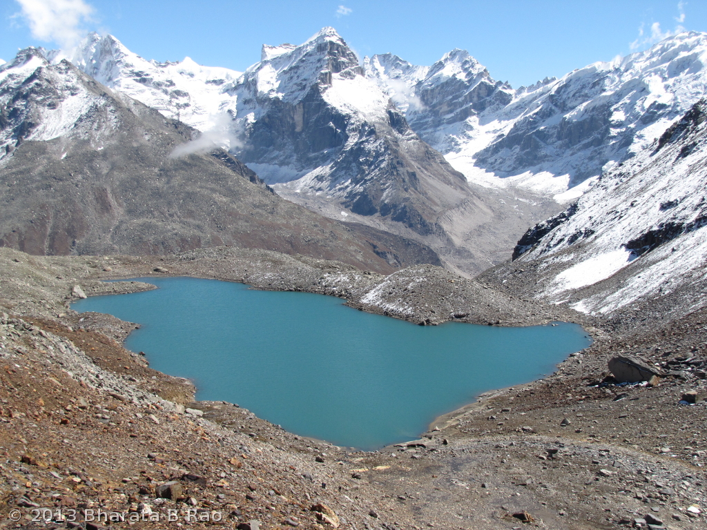
The ascent continued over rocks and rubble and we reached a lake (4340m) at 11.25AM.
The lake near Animal Pass
On the other side of the lake was the Animal Pass. The blue coloured lake was very beautiful and the 360° view around the lake was breathtaking. While Venu preferred to stay put at the lake, the rest of us continued towards the Pass. First we had to reach the other end of the fairly big lake by negotiating the boulders. Next it was a steep climb over loose soil and small rocks. Kaushal and Bhagwan were leading and it was difficult to climb in their pace. Towards the end, I lost them both in the front and also Preeti and SK being led by Chander at the back. I reached Animal Pass (4500m) at 12.40PM.
The Animal Pass as seen from the lake below it
While Kaushal and Bhagwan proceeded further up towards the right of the Pass to check out the views from there, I was satisfied to catch a glimpse of Deo Tibba (6001m) from Animal Pass and remained there.
Deo Tibba as seen from Animal Pass
To the left of the Animal Pass, raises a rocky peak called Ali Ratni peak (5490m) as per Kaushal.
Ali Ratni Tibba in the background of Animal Pass
After a few minutes Preeti with her hand firmly in the able hands of the guide Chander arrived followed by SK. Preeti didn’t let loose of guide’s hand till she reached back the campsite safely! Another member who reached the Pass without much fuss was our dog which even stepped onto the snow and rolled over it to cool itself down.
We started back at 1.40PM and took the left bank of the lake while we had ascended on the right bank. When we reached the end of the lake where we had started out from, we had done one circumambulation (parikrama) of the lake! We joined Venu near the lake at 2.30PM. For the descent we took a slightly different path and did a steep descent of a huge grassy mountain face to reach the Tosh river bed instead of taking the original route which had many ridges to negotiate. The clouds were coming pretty down sometimes and walking in the midst of the clouds was some experience.
The final descent from Animal Pass
Naren had returned back with the porter after having reached 4200m. He hadn’t acclimatized fully yet and Kaushal indicated that it will be risky to ask him cross Sara Umga. Naren and I deliberated over our next course of action. While Naren said he is willing to return back the next day with Saro’s team, I suggested that he could try coming till next campsite Kuta Thach and remain there while I try to reach Sara Umga and come back. So crossing Sara Umga plan was thus dropped.
Day 5: Shamshi Thach to Kuta Thach
Saro’s team’s mission was accomplished and they were ready to return today. They had decided to cross Sharam and reach Buddhaban in a day and reach Tosh/Manikaran/Manali on the next day itself. In the morning Naren appeared quite OK and he said he can make it to Kuta Thach but at his own slow pace.
At 8.30AM we bid goodbye to Saro’s team members who were on their way back. At 9.45AM Naren and I along with Kaushal, Chander and two porters started towards Kuta Thach. The Mumbai team had arrived at Shamshi yesterday evening and were also moving up to Kuta today. The trail had an initial climb just after Shamshi. The Mumbai group members who were carrying their day packs themselves were struggling on this stretch and so was Naren. However Naren was able to overtake the Mumbai group and make progress.
The full glory of Tosh glacier
Ice ends and the water begins – The origin of Tosh river
At around 11.30AM we were very close to Tosh glacier and we could see the snout of the glacier from a short distance. At 12.30PM we touched 4000m and from here it was mostly a walk on the level ground without much of an ascent. At 1.15PM we reached 4045m where we finished our packed lunch which consisted of 2 chapatis. At 1.50PM we walked past a possible campsite which had no water source at this time of the year.
At 2.10PM, we could see the campsite and Kaushal went ahead while I waited for Naren to catch up. At 2.30PM we crossed multiple streams which included a major one which needed assistance from the guide for crossing. We reached the Kuta Thach campsite (4065m) at 2.30PM. What could be attained in less than 2hours was done in 4.45hours since Naren’s was struggling a bit.
Kuta Thach campsite
Kuta Thach wasn’t as pleasant a campsite as Shamshi. It was in the middle of a rubble and looked like a place unfit for human habitation. A tiny stream flowed beside of our campsite which now consisted of 2 dome tents and 1 pyramid shaped tent for porters. The stream water had to be sieve-filtered since it had too many organic floating matter. The campsite was right beside the glacier and a 50m descent towards our right would have landed us straight on the moraines of the glacier.
Minimal kitchen supplies were being carried and we had to be content with half-cooked MTR pulao. Naren wasn’t doing good and I was hoping a night’s rest would serve him good. Naren had by now developed diarrhea for which he took some medicines from a doctor who was present with the Mumbai group.
Clouds started closing in around the campsite by 3.30PM. Maggie noodles was served as snacks and Rice and Sambhar were cooked for dinner.
Day 6: Kuta Thach to Shamshi Thach
The noise inside the tent when it rains doesn’t usually bring in a good feeling. This noise started during the later half of the night and continued well into the morning. We had planned to start the hike to Sara Umga pretty early in the day at 7.30AM since it would take at least 8-10 hours from Kuta to reach the Pass and come back. Any hopes of doing Sara Umga today were all washed down when it started snowing and the visibility was reduced to a few meters. It was as if the entire Kuta camp was engulfed in the clouds. The Mumbai group started to descend even while it was raining. Naren’s diarrhea had turned into stomach pain by now and the doctor suggested him to take antacids before he left.
Snow at Kuta Thach
We had an extra day and we could have stayed at Kuta today to see if the weather clears tomorrow. But Naren’s condition needed immediate descent and his body had failed to acclimatize. As soon as the weather cleared, we started the descent at 11.30PM. The descent back to Shamshi turned out to be very long since Naren was finding it difficult to walk even 10 steps continuously without a break. Kaushal and I would walk ahead, then wait for Chander and Naren to catchup. In the middle of the descent, after looking at Naren’s condition, I decided to stick with him. His progress was painfully slow while he was having regular painful stomach spasms. With continuous pushing and encouragement, I managed to get Naren to the campsite at 4PM. Naren’s condition was very similar to what he had undergone last year when crossing Kalihani Pass.
We had a good lunch, thanks to the cook Kishen at the Italian camp. It started raining at 5.15PM.
Day 7. Rest day at Shamshi Thach
Since we had enough days left and since Naren was yet to recover fully, we decided to spend a day at Shamshi. I got up leisurely at 6.30AM to find the sky mostly clear. The Sara Umga pass visible at a distance was slowly getting covered by clouds and became completely invisible by 8AM. So even if we had stayed back at Kuta yesterday, in all probability we couldn’t have made it to the Pass given the weather.
We had planned for a minor hike in the surrounding hills, but I could only do a bit of ascent to the waterfalls area. This waterfalls was the source of all the streams near the Shamshi campsite. The weather turned dull and was pretty fickle. It would be sunny one moment, only to become cloudy and drizzly the next moment. All we could do was to sit inside our tent and go to kitchen tent at regular intervals for breakfast, lunch and dinner.
The train of cloud as seen from Shamshi
One has to spend an idle day in the mountains to really understand how boring it can be in the mountains with nothing to do for the day! Here is a quote from Eric Shipton’sUpon that Mountain that best describes our mood on this day:
I doubt if anyone would claim to enjoy life at high altitudes — enjoy,
that is, in the ordinary sense of the word. There is a certain grim satisfaction to be derived from struggling
upwards, however slowly; but the bulk of one’s time is necessarily spent
in the extreme squalor of a high camp, when even this solace is
lacking…… except for the briefest moments, during which one is not
usually in the mood for aesthetic enjoyment, there is nothing to look
at but the bleak confusion inside the tent and the scaly, bearded
countenance of one’s companion — fortunately the noise of the wind
usually drowns out his stuffy breathing; worst of all is the feeling of
complete helplessness and inability to deal with any emergency that
might arise. I used to try to console myself with the thought that a year
ago I would have been thrilled by the very idea of taking part in
our present adventure, a prospect that had been seemed like
an impossible dream; but altitude has the same effect on the
mind as upon the body, one’s intellect becomes dull and unresponsive, and my only desire was to finish the wretched job and to get down
to a more reasonable clime.
Day 8. Shamshi Thach to Tosh to Manikaran
The morning was extremely cold and the surroundings had turned slightly whitish with bits of snow and ice all around. The first thing I told Naren in the morning was “Naren, I think …”, the rest was filled in by Naren himself when he said “‘… we should attempt to reach Manikaran today”.
So we started at 8.30AM and made some good progress. While I was accompanying Kaushal, Chander was coming with Naren. As we descended more, Naren’s condition improved dramatically. We reached Sharam Thach at 10AM, Shiyadi Thach at 11.50AM, Buddhaban at 12.45PM, Kulta at 1.20PM and Tosh at 2.15PM. I met the Kutla’s shopkeeper from whom I had borrowed the walking stick and promptly returned it to him. He was impressed that this walking stick had reached Animal Pass!
From Tosh, we took a taxi and come to Manikaran at 3.15PM. The first thing we did in Manikaran was to take a dip in the hot water springs. The sulphur springs had such a soothing effect that we came up from the Kund with no pain in the body whatsoever!
Apparently the Goddess scorned our softness. She also rammed home
the message that success does not depend on money. This was my
most costly expedition and it proved to be the least fulfilling.
My financial graph showed clearly that the tighter the funds,
the more memorable the outcome. Nothing in Nanda’s domain is
won easily.
Bill Aitken The Nandadevi Affair
And I couldn’t agree more with Bill – nothing in Himalaya’s domain comes easily.
After my last Himalayan trek to Auden’s Col in 2008, the only next opportunity came in 2012 when everything looked set for another sojourn to Himalayas. Naren and I started checking out the possible routes in the beginning of the year and Mayali pass trek excited us. Kaushal Desai from Above 1400ft who had taken us to Roopkund trek in 2006 was ready to arrange this trek, but he also suggested an equally challenging Bara Bhangal Trek in Himachal Pradesh Himalayas. Bara Bhangal trek looked very interesting to us since it involved an ascent to cross one pass, then a descent and a 2nd ascent to cross another pass. Given that Kaushal had already done this trek earlier, we decided to settle for Bara Bhangal. The trek was scheduled for end of September and beginning of Oct 2012. Given that this was the last trek of the season, we were assured of snow and extreme cold weather during the trek. Initially 6 of us planned to do this trek, but eventually only 4 made it. In addition to me, the group had Naren whose last trek to Himalayas was to Roopkund in 2006, Pradeep – my cousin for whom this was the first Himalayan experience and Vijay – Naren’s friend who had done Roopkund two years back.
We had a morning flight from Bangalore to Delhi and hence had to start quite early from home. Most of us had been busy with work lately and had stretched well into the night the previous day. We had a 5PM Dev Travels volvo bus from Delhi to Manali whose place of departure wasn’t fixed. We were told to board the bus from Sri Lanka Bhavan, Cannaught Place after we landed in Delhi. Accordingly, we proceeded to Cannaught Place, finished lunch in a restaurant and spent most of the afternoon in AC indoors rather than in dusty and hot Delhi outdoors. Coming from Bangalore, where both public and private bus transports operate very methodically, we were prepared for some chaos in the bus arrangements in Delhi, where double booking of seats seem to be the order of the day. The only improvement I observed this time was that the bus didn’t have any seat numbering and hence there was no scope for any claim and quarrel! We had to settle for one row backwards. On routes such as this (Delhi-Manali) where typically there are no repeat travelers, the bus operators rule the roost with utter disregard to customer quality of service. We reached Manali at 8AM the next day and checked into Taj Palace Hotel.
Day 0 (29Sep). Acclimatization in Manali
Manali is at an altitude of 1850m, as per my altimeter watch. The Mall road in Manali is very inviting and we spent a few hours shopping warm clothing for our families. Next as part of acclimatization plan, we walked for around 2km and gained 150m altitude to reach Hadima temple. Hadimba temple is dedicated to Bheema’s Rakshasi-wife Hidimba. The temple has an interesting architecture and is made completely out of wood.
Hadimba Temple, Manali
After lunch we met Kaushal who briefed us about the trek. We were a bit disappointed to know that he wasn’t accompanying us but his friend would be guiding us on the trek. In the evening, we visited the Vashist temple at 2000m. There is a hot sulphur spring behind this temple where one could take bath. We prayed for a smooth trek in the adjoining Rama temple and decided to reach Manali by walk (around 2km). Shop keepers kept pestering us to visit them and have a look at “Chingu”, but none of them was ready to explain what chingu is. As per them, chingu can’t be explained but should be experienced by seeing! Finally out of curiosity we decided to checkout chingu and entered a shop. Chingu is essentially a blanket made of high quality wool (Pashmina goat’s probably) and it is apparently so expensive and valued that its not sold, but is instead rented out! The shop keeper went on and on about chingu and showed us all the valuable gifts we get if we were to rent out an expensive chingu. He was ready with address and contact details of hundreds of Indians and foreigners who had bought chingu on rent. Unwilling to be part of his fooled-buyers’ list, we came out.
No discount, no bargaining, no tension!
Late evening was spent in the gullies of Manali. The night turned to be nightmare for us when Naren and I discovered hundreds of bed bugs in our room. We were promptly shifted to an adjoining hotel at 11PM in the night while Pradeep and Vijay were having sound sleep in the next room!
Day 1 (30Sep). Manali to Lama Dugh
Lalith, Kaushal’s friend and our guide to Bara Bhangal trek, picked us up from the Hotel in the morning and we reached Kaushal’s house which is near the Hadimba temple. Lalith hails from Jibhi, Himachal Pradesh and is an accomplished mountaineer. He runs his own adventure treks and climbs too. We met our cook Hansraj and Horseman Shyam at Kaushal’s place. So totally we were a group of 7 with 4 members, 3 support staff and 1 horse and 8 mules. After tea at Kaushal’s house we hit the trail (2000m) at 10AM. The trail starts right in front of Kaushal’s house and proceeds into the pine forest. Thanks to our mini acclimatization expeditions yesterday, all of us felt comfortable in negotiating the initial steep uphill climb. At 11AM we reached a landmark called Bada Pathar (2260m) which was in the midst of a tiny forest clearing. Good views of Manali city can be obtained from this point. Indrasan peak was visible from here.
Trail leading to pine forest
Next part of the trail was again steep ascent in the pine forest and we reached 2800m at 1.15PM. From here, the trail is along the water pipeline that runs from above till Kaushal’s place. As we reached higher, the pine trees mostly gave way to plants which were head-high. We reached Lama Dugh camp site (2900m) at 2PM.
Campsite at Lama Dugh
The camp site had a small stream that served as our water source. The camp site was beautiful with greenery all around. Horses reached shortly afterwards. The tents were pitched and lunch (Biryani Rice) was provided at 3.45PM. After lunch we did a small uphill climb of 150m to help us acclimatize better. We could still get mobile signals from here. 150m above our campsite, there was a shepherd camping with his sheep. A shepherd dog followed us on the trail and even returned to our camp site.
Day 2 (01Oct). Lama Dugh to Riyali Thach
I got up at 5.30AM, the temperature was 7°C. We had roasted wheat bread and banana for breakfast and a hot cup of tea. One of the specialities of Roopkund trek with Kaushal was rich food and we had explicitly requested him to keep up the standards 🙂 It was 8.30AM by the time we started the day’s hike. Initial path led us up to the shepherd tent where we could see the Manalsu stream flowing down. This stream would eventually join the Beas river. From this height, Dauladhar range was visible towards the West, Peer Panjal towards NE and Rohtang Pass was visible towards North.
Shepherd tent near Lama Dugh
We reached 3165m at 9.30AM and 3400m at 11AM. Now we were truly past the tree line. It was a continuous but gradual ascent and first glimpse of Kalihani pass was visible at 1.15PM from the height of 3565m. By now the horses went past us. At 12.35PM we climbed on to a ridge and reached the highest point for the day at 3770m. It was extremely windy, but the surroundings were spectacular. Greater Himalayan range and Deo Tibba peak were visible from here. We spent a few minutes taking photographs from this ridge.
Next part of the trail was a continuous descent until the camp site. First we descended rapidly into a monstrous valley, crossed a stream and continued the descent. We could see our kitchen tent down below towards our right and were about to descend straight when we saw our guide waiting for us at a vantage point towards our left. Apparently he had chosen a bit more circuitous but easier route to descend. A group of Britishers led by a Nepali Sherpa had joined us by now. All of us reached Riyali Thach camping site (3335m) together at 2.30PM. We were welcomed with a cup of juice and later tea. Naren looked tired and he attributed that to lack of lunch at the right time.
The camp site was beside a stream which served as our water source. After lunch we did a small acclimatization ascent of around 150m.
I had a sumptuous dinner of roti-subzi and dal-chawal, hit the bed at 8.30PM and had a good night’s sleep.
Day 3 (02Oct). Riyali Thach to Kalihani base
I got up at 5.45AM, the outside temperature was 3°C. It was too cold to attempt brushing of teeth. Bread, fruits and cornflakes were provided for breakfast. At 8.30AM we started the trek. First we had to cross a big herd of sheep. The initial part of the trail involved walking alongside a stream that would eventually join the Fulez Nala. At 10AM we went beyond a snow bridge and crossed over to the other side of the stream. I slipped over during river crossing resulting in both my shoes becoming completely wet. Fortunately it was very sunny and I could manage with a change over set of socks from Lalith.
Ridge enroute Kalihani base
At 11AM we reached a height of 3500m and we were on a ridge. From here it was a continuous walk along this ridge. By this time I was in a rhythm and left others behind to continue the ascent in my pace. I reached 3600m at 11.30AM and 3700m at 11.45AM. Here the ridge ended and a steep ascent over a zig-zag path started. I reached 3800m at 12PM and Pradeep joined me here for finish the packed lunch which we were carrying. Naren had finished his lunch much earlier and was experimenting with a slow pace and hence reached a few minutes late. 5min ascent further led to a flat land (plateau) from where our campsite was visible. We spent a few minutes to enjoy the sunny midday and took photographs of the surrounding mountains. We reached Kalihani base camp (3825m) after crossing a moraine at 1.30PM.
Indrasan (left) and Deo Tibba (right) as seen from Kalihani base
Day 4 (03Oct). Crossing Kalihani pass
At 3AM I was woken up by the sound of sleet shower hitting the tents. Heavy snow or shower would reduce our chances of crossing the Kalihani pass today, but fortunately it lasted only for around 30min. We got out of the tents at 4.30AM, the temperature was 2°C. The surroundings were all white, thanks to the snow. We finished early breakfast of oats and tea and got all set to hit the trail. Fortunately as per Lalith’s estimate, the clouds subsided and Sun rose behind the Deo Tibba at 6.15AM. We started the hike at 6.30AM.
First bits of snow enroute Kalihani Pass
The initial part of the trail was an ascent through moraine and I reached 4020m at 7.10AM. I spent over 20min here for rest of the group to catch up. Next stretch of the trail involved steep ascent over scree. At 9.30AM, I touched the snowline at an altitude of 4435m. I saw Lalith’s footsteps but he was nowhere to be seen. Rest of the group was far behind. I had reached a flat ground covered with snow and finally saw Lalith at a height exploring the route towards the pass. Rest of the group joined us after half an hour.
A View enroute Kalihani Pass
Mountain range seen from Kalihani Pass
The next part of the trail was through moraine with snow. I reached 4450m at 11AM. The going was tough since the altitude was making our progress slow. As we gained height, we were mostly walking over a feet of snow. Naren and Pradeep were suffering from mild altitude sickness. While Pradeep closely followed me, Naren’s progress was slow. Vijay was coming with Naren. We still had to walk 5hours on the other side of the pass to reach our designated camping ground. Horseman was keen to know if he should stop the horses at some intermediate point or should make it to the eventual camping ground at Devi Ki Marhi. After some deliberations with Lalith, we decided that we will do the full day trail today and camp at Devi Ki Marhi. Since the progress of Naren and Vijay was too slow, I decided to stick with them to motivate them to move fast.
The Kalihani Pass
At 12PM, we finally made it to Kalihani Pass at 4645m. The packed lunch was finished on the Pass. We spent around 30min on the Pass and started getting down on the other side. The initial trail was a gradual descent through the snow. We went beside 3 beautiful lakes during the descent. We had now joined Kalihani Nala and were mostly walking beside it over the moraine. It was a long and tiresome walk over the boulders. At 3.30PM we reached the place (4055m) where the British group had camped. They offered us hot tea which was badly needed by us. Devi Ki Marhi camp was still 3 more hours away and one trekker from the camp remarked that we are indeed brave to attempt that. I wasn’t sure if we were brave or stupid at that time 🙂
The descent
Next it was a long monotonous walk alongside the river. Horses were well ahead of us and Lalith was nowhere in sight. Pradeep, Vijay and I were walking together in an increased pace while Naren was trailing behind. As we progressed ahead, we completely lost both Lalith in the front and Naren at the back. Many times we would see a huge rock at a distance that would appear exactly like our kitchen tent but only to be fooled later. The walk turned a bit more challenging when sleet shower started at 5.30PM. Though we were equipped to walk in sleet shower or snow or rain, it was seriously hindering our visibility as it was turning dark quickly. We finally saw Lalith coming back in search of us. After 30min walk in the shower were came across a shepherd shelter (built of stones) where we decided to wait for Naren and Lalith.
Lake on the other side of Kalihani Pass
Shepherd tents are so well designed that one could easily spend a night in them in times of emergency. There was a fireplace within the shelter. Lalith started the fire and left us to find out how far our campsite was. We sustained the fire till 8.30PM when Lalith was back with Hansraj who served us much needed noodles. Naren had high fever by this time and had already vomited once. It took some amount of persuasion to get him consume food and get started towards our campsite. We left the shepherd shelter at 9PM and slowly started moving towards Devi Ki Marhi. The going was very tough since our pace was too slow for the guide and it was taking huge effort for Naren to even move a step further. He was feeling so sleepy that given to himself, he would have slept there on the trail itself. Again it took us some effort to motivate Naren and it was 11.15PM by the time we reached the camp site of Devi Ki Marhi at 3555m. The only positive aspect of the night trek was the spectacular moonrise behind a peak, the moonrise never looked more beautiful. Looking back we feel we had done 2 days or at least 1.5 days worth of hike in a single day. Kaushal’s original itinerary for this day was a bit over-optimistic.
Day 5 (04Oct). Devi Ki Marhi to Dal Marhi
Previous day had been very tough and I got up late at 6.15AM, the temperature was -5°C. As usual our camp site was on the banks of a stream (Kalihani Nala) and I could see our horses grazing at a height across the Nala near Devi Ki Marhi temple. (Temple was just a miniature shelter for God built of stones). I could also see horseman enjoying the morning camp fire near a shepherd tent across the Nala. I quickly joined him since any fire is so inviting at such chilling temperatures.
Horseman Shyam enjoying early morning fire near a shepherd shelter
Devi Ki Marhi campsite
I was apprehensive if everyone in the group would have enough energy today to even start the day’s hike, but fortunately everyone including Naren who was still suffering from fever, agreed to continue the hike and shift our base to the next camp site Dal Marhi today. We started at 9.30AM and crossed a stream over a bridge which consisted of flat stones laid over two pine logs.
We were walking alongside this stream
The day’s trek mostly involved walking beside the river and crossing moraines every now and then. We crossed a few streams that were joining the main Kalihani Nala. At one place, I removed my shoes and crossed the river barefoot for the fear of accidentally soaking my shoes. At around 11.45AM we were atop a small hill measuring 3415m. The highlight of the day’s trek was crossing a land slide area which was so slippery since the loose soil barely provided any grip. I crossed the 10ft stretch by sitting down while rest of the group took Lalith’s help. At 2.15PM, I had reached the base of a ridge at 3275m which required straight ascent. It took half an hour to reach the top at 3450m. We had to immediately descend on the other side, cross a stream that required Lalith’s help and then continue the ascent. It was Naren’s turn this time to soak the shoes in the river!
Vijay negotiating the landslide area
Pradeep and I gradually increased our pace and reached the Dal Marhi camp site (3660m) at 4.15PM. Naren and Vijay came in after 30min. The camp site was beautiful with Dauladhar range behind us. We were in Himayalan Bear territory now and we could see bear excreta at many places in the campsite as well as the trail.
Day 6 (05Oct). Dal Marhi to Bara Bhangal
Naren wasn’t feeling well through out the night and finally I had to wake up the cook at 5AM to prepare hot tea for him. I couldn’t get sleep again and roamed around the campsite for a bit before settling down to do some Pranayama. I was distracted by the sound of stones falling down from the landslide area in front of our camp site. The camp site was surrounded by high-rise hills and hence sun rays didn’t hit the campsite even hours after sunrise. -1°C was recorded at 7.30AM. Nothing usually gets done until Sun is out and hence we had a delayed start at 9.45AM.
Dauladhar range as seen from Dal Marhi
The day’s hike started with a steep ascent but was mostly downhill for rest of the day. At around 11.30AM, we had reached tree line and were walking beside rhododendron, birch and pine trees. I really dislike descending since its so hard on knees. Stepping down sideways to avoid pressure on knees would eventually lead to pain in the ankles. At 3PM we had reached 3000m after which we did a 300m straight descent. Naren was doing well and was leading the group while I remained at the end. At 4PM we had reached the outskirts of Bara Bhangal village where we could see the cultivated fields. Pradeep showed us Ganja plants and it appeared that the villagers were growing them freely everywhere. The final descent was very tough and tiring, I eventually reached Bara Bhangal village (2455m) at 4.30PM.
Shephard shelter enroute Bara Bhangal
The campsite was beside a Government school. Ravi river flowed across our campsite. Pradeep got acquainted with the teacher of the school and brought him to our camp site. Masterji was kind enough to escort us through the village by-lanes. Bara Bhangal has a population of around 750, limited power thanks to a mini-hydel project and a satellite phone that works for 3 hours a day. We could see people mainly growing Rajma and corn in the village.
Bridge across Ravi river in Bara Bhangal
To reach any village or city from Bara Bhangal one has to either go back and climb Kalihani Pass or climb and cross the Thamsar Pass. So having come till Bara Bhangal, we had no easy exit paths, we had to cross another pass to get back to civilization. This hardship came as a surprise to some of our team members but that only increased their resolve to complete the trek and get back to a safer place!
Day 7 (06Oct). Bara Bhangal to Mardh
Camping at low altitude in Bara Bhangal gave me an opportunity to brush my teeth and wash my face after a gap of 5 days! We started the hike at 8.15AM. First we crossed the Ravi river and started ascending on the right bank of a stream. The ascent was mostly steep and all of us were doing pretty good since we had acclimatized well by now. Today our guide didn’t start with us and we were all by our own. There was a path leading down to the stream and a possible opportunity to cross over to the left bank of the stream, but we ignored it owing to the sparse usage of the path. We continued to ascend on the right bank of the stream and reached 3050m at 11AM. By now we could see a clear path on the left bank as well. Unable to decide the route, we waited for the guide. The guide and the horses appeared at 12.45PM, but on the left bank of the stream. We had lost precious 1 hour 45min in the mountains and we were on the wrong side of the river! It was impossible to cross the stream due to strong currents and we had to climb further up and cross over at a more safer point.
A peak seen from Mardh
We finished lunch and started the further ascent through moraine that consisted of huge rocks. By 2PM we were pleasantly surprised to find ourselves in the campsite of Mardh (3400m). This camping site was apparently chosen to provide grazing opportunity for the horses which wouldn’t have been possible if we had camped any higher and nearer to Thamsar pass.
Pradeep and Vijay (Right) helping Lalith (Left) to pitch the tent at Mardh
Having reached earlier than anticipated, Pradeep, Vijay and I did a small acclimatization trek to keep us in good shape for the big day tomorrow. Vijay was in mood for some talk and he described the life around the Ranganatha Temple in Srirangam, Trichy, TN and also gave us a good account of the history of Sri Ranganatha during the times of Muslim onslaught. Spirits were up in the kitchen tent too and Lalith prepared Pakodas for us!
Day 8 (07Oct). Crossing Thamsar Pass
We had a very long day when we crossed the previous Pass (Kalihani) and hence wanted to make sure that we start early this time to give us enough buffer time. I got up at 5AM, the temperature was 0°C. After breakfast that involved oats and cornflakes, we started the trek at 6.30AM. We made good progress initially and reached 3800m at 8.15AM. Next we crossed over to the other bank of the Thamsar stream and reached a shepherd tent that could have served as a campsite. Looking back I felt we should have camped here the previous night which would have given a good head start for attempting the Pass. Lalith spotted 4 grazing animals on the top of a high mountain. They were appearing as tiny black dots to the naked eye. We suspected them to be bears, but on camera they appeared more like yak than bear.
We crossed these mountains via Thamsar Pass
At 9.45AM, we had reached 4030m from where Thamsar Pass became visible clearly. Next we had to cross a tiny stretch of glacier and another 100m ascent took us to the banks of a huge lake. We had an early lunch here and started the ascent beside the beautiful blue lake. At 12.15PM, we touched snowline at 4300m. At 12.45PM we were at the base of Thamsar Pass with a frozen lake (4375m) separating us and the Pass. Unlike the approach to Kalihani Pass, the final approach to Thamsar Pass was easy and it involved a gradual ascent path that circled around the frozen lake.
Way to Thamsar Pass
Lalith was the first to reach Thamsar Pass (4520m) followed by me at 1.20PM. I thanked the Mountain God stationed on Thamsar Pass for allowing us the safe passage. The weather which was kind till now suddenly changed. We could spare only 20min on the Pass and sleet shower started. All of us practically rushed down on the other side. It was continuous descent from here onwards and we reached a possible campsite (3900m) at 3PM. The horseman had a better campsite in mind and we continued the descent. By now the sleet shower had turned into snow fall and was gradually getting heavier. Thanks to the snow, reaching a campsite was the only thing in our minds and hence all pain in the knees and ankles were almost forgotten! We reached an empty shepherd house (3400m) built of stones at 4PM. It had two rooms and served as good shelter for us in the night. The snowfall continued almost till 5PM. As per Kaushal’s itinerary we were supposed to reach Plachak camp site today. From Mardh, it involves an ascent of 1km and a descent of 2km which is probably too much to cover in a day.
Mountain range seen from Thamsar Pass
Clouds closing in from the other side of Thamsar Pass
We had crossed two mountain passes successfully and celebrated the achievement by lighting a huge campfire. All the firewood in the shepherd shelter was consumed in the night. The taste of piping hot ginger lemon water with honey on a moonlit night in the mountains will remain with me for years to come!
Day 9 (08Oct). Back to civilization
We started the last day of the trek at 8.30AM in the morning. As per itinerary, we were supposed to reach Billing by walk and then proceed to Bir and from there Dharamshala. But since that was too much for a day, our horseman Shyam suggested an alternative – reach Bada Gaon and from there travel on road to Dharamshala. The last day’s trek is usually tricky since there is no challenge to look forward to. When you are expecting a quick finish to the day, the long walk to the destination could mentally wear you down. This happened with us too, walk to Bada Gaon turned out to be a long one.
The proud group L2R – Hansraj the cook, Naren, Shyam the Horseman, Me, Pradeep and Lalith our guide
Its business as usual for these Bara Bhangal kids who cross Thamsar Pass every year before the winter sets in!
We had to cross 4 ice bridges over Barot Nala today and that was the only excitement to otherwise monotonous descend through pine forests. We reached Plachak (2565m) at 11.40AM. From Plachak, the route crosses over to the right bank of the river and continues further in the pine forest. At 2PM we crossed over to the left bank over a bridge and from here it was an hour’s walk to our destination. We were at Bada Gaon (2270m) at 3PM. Lalith had to hitchhike in a car to reach Barot to fetch us a taxi from Bada Gaon to Ghattasni. At Ghattasni we changed over to another taxi to reach Dharamshala at 10PM.


 Posted by Bharata