Trek to Devkara falls

October 2, 2015

Devkara is a small village present in the border area of Yellapura and Karwar. Now it is mostly an abandoned village thanks to relocation after Kadra and Kodasalli dam projects.  But this village hides a natural treasure, a spectacular waterfalls which the locals call Devkara Vajra. Devkara stream falling from approximately 200-300m height near Devkara village forms this waterfalls. Devkara stream  eventually joins the Kali river. This falls can be approached from the Kadra side as well as from Yellapura side. Here is my story of multiple attempts to reach this waterfalls from Yellapura side.

1st attempt

In May 2014, my brother-in-law and I rode a bike from Sonda, Sirsi, traveled to Yellapura and then to ಈರಾಪುರ village. We hardly had any information about the falls then and unfortunately we couldn’t reach anywhere near the waterfalls. All we could get was this distant view of the Kodasalli back waters.

Kodasalli backwaters

Kodasalli backwaters

However we did establish a local contact who agreed to take us to the falls next time.

2nd attempt

I was at Sonda, Sirsi in the first week of Oct 2014 and took that opportunity to revisit Devkara falls. This time we reached the local contact’s place at  ಈರಾಪುರ village and started trekking in the forest route at 10AM. Along with the guide, our local contact was accompanying us with his school going son. The guide took us on a circuitous route and we first reached very close to Kodasalli reservoir at 11.30AM.

Kodasalli dam

Kodasalli dam

We were walking on a mountain range overlooking a valley in which Kali river was flowing. On the opposite side of the river was another range where the waterfalls was present. After walking through the forest for an hour, we finally emerged out on top of the mountain range at 12.30PM. This place was called ಹಬ್ಬು ಕೋಟೆ/ಕಟ್ಟೆ and it provided good view of the distant waterfalls. From that far off distance the falls looked so big and we wondered how gigantic it would it appear from the base. Unfortunately we hadn’t planned for a day long trek and we were just carrying a few raw cucumbers and butter milk which we completely finished at ಹಬ್ಬು ಕೋಟೆ.

Distant view of Devkara falls

Distant view of Devkara falls

Since reaching the base of the falls from here was out of question, our guide offered us to take us around a bit and show us a few places of interest. Thus we proceeded ahead on the same mountain range and reached a place called ದೇವಿಮನೆ. This is some sacred place in the hills where the villagers would come and offer prayers once in a year in November. From this place we did venture ahead a bit to get a clear view of Kadra reservoir. Instead of returning back via the same route, our guide suggested that we could do a full circle by getting down to Devkara village and then climb up ಬೆಂಡೆಘಟ್ಟ to reach back ಈರಾಪುರ village. We didn’t really know how much time and effort that would take, but just agreed.

After a steep descent we were at Devkara village at 3PM. The village is mostly deserted with a few houses still remaining. There is a Ramalingeshwara temple in the village where Pooja is done once a week. A priest comes from a far off distance every Monday for this purpose.

Devkara village

Devkara village

Ramalingeshwara temple, Devkara

Ramalingeshwara temple, Devkara

We were now walking beside the Kali river. A trail exists from Devakara till ಬೆಂಡೆಘಟ್ಟ, but were dead tired since we hardly had any solid food since morning. The journey seemed endless and we finally reached the foothills of ಬೆಂಡೆಘಟ್ಟ at 4.15PM. The climb up is abruptly steep and it took quite a bit of effort and time to reach the top at around 5.30PM. Our enterprising guide could find some tender coconuts in an abandoned house and that came as a big relief to us. But the relief was short lived as it started raining. By the time we reached our local contact’s house, we were completely drenched. We consumed the food that we we had planned to have for lunch here and started back on bike towards Sonda at around 6.30PM. Next 60km drive through the winding forest roads was mostly treacherous with non-stop hard rain. Our adventure finally ended when we reached home at 9PM.

3rd attempt

Though we had seen the waterfalls, that was hardly satisfying since we hadn’t been able to reach the base of the falls. So last week we made another attempt to reach the falls. This time I took Naren with me to my in-laws place. My brother-in-law found a person from Devkara village itself who had relocated to Sonda. He was ready to guide us and we thought our 3rd attempt should be a success since the guide was born and brought up in Devkara village and he should be able to guide us to the base of the falls.

4 of us started in 2 bikes at 8AM from Sonda and reached ಈರಾಪುರ village at 10AM. Thanks to two wheelers, we were able to cover some trail distance too on bike. At 10.30AM we were at the starting point of ಬೆಂಡೆಘಟ್ಟ (470m) from where we had to descend. At 11AM we reached 130m and touched a flowing stream locally called  ಈರಾಪುರ stream which eventually becomes Kali river.  We walked towards Devkara village alongside the stream and at one point, the falls becomes visible towards our left.

At 11.45AM, we reached 70m and crossed the stream which was utmost knee deep. Next we had to cross another stream that flows from Devkara falls and joins the stream that we just crossed. This stream was flowing with good speed and we had to find a suitable place to crossover. Thanks to our guide, we did find a reasonably safe place to cross the stream where the water was thigh deep at places. We were able to cross it with reasonable ease using sticks for support. We were now at the periphery of Devkara village and were walking along a few abandoned houses and paddy fields.

IMG_5794

Next it was some hide and seek with the waterfalls as it is located in such a place covered with dense forest towards its approach that it is not visible at every point on the approach path. There was no well defined path to the falls, but we had to make one by clearing the forest growth and following the general direction of the waterfalls.

Devkara falls

Devkara falls

At 1PM we reached a rocky clearance from where the falls was visible fairly clearly. Based on our last year’s experience, we weren’t taking chances with food and hence were carrying sufficient amount of Pulao, home grown cucumbers, butter milk and ಚಕ್ಕುಲಿ. We finished lunch on these rocks. We had still not reached the exact base of the falls and hence ventured into the forests a bit more to check if better view of the falls could be had. At 2PM we reached another rocky clearance from where we had a decent view of the falls. We decided to end the quest here since the path ahead to the ultimate base of the falls was difficult and it was already well past midday.

IMG_5812IMG_20150926_140739788_HDR

On the way back, it took two hours for us to reach ಬೆಂಡೆಘಟ್ಟ base and after an hour we were back at ಈರಾಪುರ village. Thus on the third attempt, we finally had satisfying views of Devkara falls! It was not just about the falls, but this also turned out to be good trek worth remembering after my previous trek in the same area.


Lesser known temples of North Karnataka II

April 3, 2010

During my last visit to North Karnataka region, I covered a few beautiful temples in Hubli-Dharwad and Gadag districts. Here are a few more jewels from the Haveri district of Karnataka.

Most of my visits to my in-laws place in Sonda have been extremely fruitful. Over the last few years, I have mostly seen all the places of interest around Sonda and Sirsi region. So these days, I am exploring some of the old temples in the North Karnataka region. During my last visit, I could not see the temples of Haveri district due to time constraint. This time I was all set with the required information and the necessary permission for photography from ASI.

I had booked a Maruti Omni for travel, however not many in the house were ready to accompany me, thanks to the harsh Sun. In this hot weather of mid march, it needs a bit of motivation to venture intosuch unknown, rarely visited temples! Finally it was me, my wife and other two kids.

Here is a list of temples in the order I visited this time:

As last time, I won’t dwell into the architectural details of the temples as these are covered in the wikipedia links I have provided with each of these temples and also I am not qualified to explain that 🙂

Tarakeshwara temple, Hangal

Hangal is at a distance of around 60km from Sonda towards Haveri.  As you enter Hangal, there are Karnataka Tourism’s sign boards to guide you to the temple. As is norm with any of such temples in Karnataka, to reach Tarakeshwara temple, one has to negotiate quite a stretch of narrow winding roads amidst human settlements to reach the temple. From the entrance of the temple, the complete temple is not visible and it looks like a normal temple. But once inside the temple premises, the grandeur of the temple becomes evident.

tarakeshwara1

The temple is huge with many decorated pillars. The main attraction is the delicately decorated huge ceiling.

tarakeshwara2

The are attractive carvings inside the temple.

tarakeshwara3

The work on the exterior of the temple is grand and noteworthy.

tarakeshwara4

tarakeshwara5

tarakeshwara6

There is a small Ganesha temple with a Nagara style Gopura near the entrance of Tarakeshwara temple.

tarakeshwara7

Billeshwara temple, Hangal

Billeshwara temple is located opposite to a lake (Anekere) on the Hangal-Bankapur Highway (SH1).

This mostly looks like an abandoned temple and partly destroyed.

billeshwara1

The Shiva Linga is unsually big.

The decorations on the temple entrance are interesting.

billeshwara2

Jain temple, Hangal

There is a Jain temple inside the fort area and in the Horticulture department premises near the Hangal bus stand. But it took some effort to locate this temple as locals hardly remembered about this, given that it is inside the Horticulture department premises whose entrance mainly remains locked.

jain1

The temple is mostly in dilapidated condition and would do good with some restoration.

jain2

Nagareshwara temple, Bankapur

Bankapur is around 25km from Hangal and is more famous for the Peacock sanctuary. Nagareshwara temple is located inside the sanctuary.

nageshwara1

The temple was undergoing restoration and was closed when we visited, but thanks to the ASI official, we got permission to enter.

nageshwara2

The temple is big with many pillars. The style of the ceiling reminds us about the ceiling of Hangal’s Tarakeshwara temple.

nageshwara3

The entrance of the Garba Griha is well decorated.

nageshwara4

There are beautiful carvings on the exterior walls of the temples.

nageshwara5

nageshwara6

Curiously a miniature coffin-like structure with Urdu inscriptions can be found in the temple premises!

nageshwara7

Siddeshwara temple, Haveri

Siddeshwara temple is located in the Agadi road in the Haveri town itself.

siddeshwara1

The temple is attractive with richly decorated Gopura.

siddeshwara2

Unlike other temples in the region, this temple is devoid of any adjoining human settlements and ASI has done a good job of maintaining the huge temple complex.

siddeshwara3

Muktheshwara temple, Choudayyadanapura

Choudayyadanapura is a village located roughly around 40km from Haveri town. Since I wasn’t carrying any map, it took some effort to find the directions to this temple. From Haveri town, proceed on the road to Agadi and after around 25km, take a right deviation into Ranebennur road to reach Choudayyadanapura.

Muktheshwara temple is located on the banks of River Tungabhadra.

muktheswara1

Temple is fairly big and has attractive exterior. Temple entrance, temple exterior and Gopura are well decorated.

muktheswara2

muktheswara3

There is Someshwara temple in Haralahalli village somewhere around this area, but nobody was able to give us right directions to Haralahalli.

Mallikarjuna temple, Kurvatti

Kuruvatti village is around 15km from Choudayyadanapura and one has to cross Mylara village (which is known for its Mylara lingeshwara temple).

Again it took some effort to locate this temple because this temple is located adjacent to a Hanuman temple which is frequented by devotees more. I had reached this temple on the day when there was some festival celebrations in the Hanuman temple and hence there were hundreds of people around. I was probably only person there who had come to visit the Mallikarjuna temple instead of the Hanuman temple! A couple of failed inquiries, one person confirmed that Mallikarjuna temple is indeed present here and I have come to the right place.

The temple is beautiful, but the Gopura has lost its original beauty since it has been painted.

mallikarjuna4

There are some exquisite carvings in the temple entrance.

mallikarjuna1

mallikarjuna3

The top portion of the Garbha Griha has some elaborate carvings.

mallikarjuna2

mallikarjuna5

Galageshwara temple, Galaganatha

To reach Galaganatha village from Haveri town, proceed on the Agadi road and reach till Guttal (25km). From Guttal, Galaganatha is around 15km.

The pain of travelling in the midday sun was all forgotten when we landed at the Galageshwara temple which is located on the banks of Tungabhadra river.

This temple is very different from other temples of the area since the Gopura seems like raising from the ground!

galageshwara1

This temple is worth visiting anytime for its uniqueness.

galageshwara2

galageshwara3

galageshwara4

After visiting all these architecturally wonderful temples of the North Karnataka region, one wonders why they aren’t in the tourist circuit of Karnataka. When it comes to temples of Karnataka, we hear mainly Hampi, Belur, Somanathapura, Badami and Pattadakal. There are so many jewels like these which are waiting to be explored.


Lesser known temples of North Karnataka

October 19, 2009

North Karnataka region has many architecturally significant and ancient temples. But a typical temple circuit tour to North Karnataka would most probably end at Badami, Aihole and Pattadakal. Here are some lesser known and lesser visited but equally beautiful temples of North Karnataka.

I was at Sirsi during 3rd week of September just before the devastating floods that engulfed North Karnataka region. Since I had a day to spare, I decided to checkout some temples in Dharwad and Gadag districts whose details I picked up from Karantaka Tourism’s handouts and later from wikipedia. Since the wikipedia links for these temples give more information than what I could potentially provide, I am mostly skipping the descriptions of the temples themselves and would only indicate how to reach the place with a few photographs of each of the temples. This is the list of temples that I covered in the order I visited.

Chandramouleshwara Temple, Unkal, Hubli

Unkal is located at a distance of around 5km from Hubli town on Hubli-Dharwad road (SH73) towards Dharwad and is close to Unkal circle and Unkal lake. The approach to the temple is horrible and you begin to wonder if you are in the right place when you have to navigate through dirty roads of a slum locality (well almost a slum). But suddenly a well maintained temple becomes visible and appears as a total misfit in the area. ASI has a pretty good job of maintaining the monument in whatever space they could get around the temple.

Chandramouleshwara Temple, Unkal
dscn3682

Decorated window, Unkal
dscn3689

Nandi on the temple wall, Unkal
dscn3699

Natya Ganapa, Unkal
dscn3698

Banashankari Temple, Amargol, Hubli

Amargol is located at around 5km from Unkal towards Dharwad on SH73. Similar to Unkal, the temple here is also located in not so good surroundings.  It took some effort to Locate the temples of Unkal and Amargol as many locals whom we enquired hardly knew about these temples.

Banashankari temple, Amargol
dscn3702

Pillar of Amargol temple
dscn3703

Amruteshwara Temple, Annigeri

Annigeri is situated at on NH63 at a distance of around 35km from Hubli towards Gadag. The main temple dedicated to Amruteshwara is very beautiful. I didn’t have time to checkout other temples in this town (Banashankari, Basappa, Gajina Basappa and Hire Hanuman) which are probably not architecturally significant.

Amruteshwara temple, Annigeri
dscn3714

Decorated wall of Annigeri temple
dscn3732

Ganesha on the temple wall, Annigeri
dscn3740

Trikuteshwara Temple, Gadag

Gadag is situated at around 57km from Hubli on NH63.

The Trikuteshwara temple complex has mainly a temple for Trikuteshwara (which has 3 Lingams representing the Trinity) and Saraswati Temple which has heavily decorated pillars. A visit just to see these pillars is worth anytime. The other temples in Gadag town are the Veeranarayana Temple where the Kannada poet Kumara Vyasa composed the epic Bharata or the Gadugina Bharata

Ornate pillar, Trikuteshwara temple, Gadag
trikuteshwara1

Pillar of Trikuteshwara temple
trikuteshwara2

Trikuteshwara temple, Gadag
trikuteshwara3

Temples of Lakkundi, Gadag

Lakkundi is situated at around 70km from Hubli on NH63 and is 12km from Gadag. Lakkundi has so many temples that the locals have put a few of these places of worship to other uses (like imaginatively constructing a house with a temple wall forming one of the walls of the house!)

A house adjacent to a temple in Lakkundi
lakkundi1

The Kashi Vishweshwara and Surya Narayana temples face each other. The entrance to these temples have very delicate decorations.

Surya Narayana temple, Lakkundi
lakkundi7

Kashi Vishweshwara temple, Lakkundi
lakkundi8

Pillar of Kashivishweshwara temple
lakkundi4

Decorated entrance of Kashivishweshwara temple
lakkundi5

Adjancent to Kashi Vishweshwara temple is present the Naneeshwara temple.

Naneeshwara temple, Lakkundi
lakkundi6

A couple of hundred meters from Naneeshwara temple,  a museum and a Jain Basadi are present.

Jain Basadi, Lakkundi
lakkundi10

Jain Basadi, Lakkundi
lakkundi14

An idol in Jain Basadi
lakkundi12

On the other side of the highway, Manikeshwara temple is present with an elaborate and stepped Kalyani (pond). In my limited exposure to temples of Karnataka, I would consider this as a unique Kalyani for this style.

Kalyani, Lakkundi
lakkundi16

Kalyani, Lakkundi
lakkundi17

Dodda Basappa Temple, Dambala, Gadag

If you have reached Lakkundi, you will repent if you return without a visit to the Dodda Basappa temple of Dambala. Dambala is situated at around 10km from Lakkundi. The village road from Lakkundi to Dambala was in a decent condition (well almost decent) during my visit.

The Gopuram of Dodda Basappa temple is simply majestic. The exterior decorations of the temple are also very good. The temple houses a Shiva Linga at one corner and a fairly big Nandi (Basappa) idol at the other end.  The platform hosting the Basappa was under rennovation during my visit. It is interesting that this temple is not known as some Ishwara temple, but is known by its Nandi (Basappa).

Dodda Basappa temple, Dambala
basappa1

Gopura of Dodda Basappa temple
basappa3

There is a small Someshwara temple just opposite to Dodda Basappa temple.

Someshwara Temple, Lakshmeshwar, Gadag

If you are in Dambala, you have two options: either go back to Gadag/Hubli via Lakkundi or proceed further to visit the temples of Lakshmeshwar and Kundgola and rejoin Hubli. One would need a bit of motivation to choose the latter option given the typical hot climate of North Karnataka and the poorly maintained roads connecting these places. I took the village road from Dambala to Shirhatti (can’t remember the exact distance, must be around 35km) and joined SH6 at Magdi (8km) and reached Lakshmeshwar (13km). Apparantely, Lakshmeshwar is directly connected to Gadag by SH6.

The Someshwara Temple at Lakshmeshwar is a fairly big and beautiful temple where daily worship is still performed.

Someshwara temple, Lakshmeshwara
lakshmeshwar1

Someshwara temple, Lakshmeshwara
lakshmeshwar2

It took me 2hrs to cover a distance of around 50km from Lakshmeshwar to reach Hubli. These (Dambala to Hubli via Lakshmeshwar) are some of the worst roads I have driven on and they can hardly be called roads. Since it was dark by the time I crossed Kundgol, I couldn’t visit the Shambulinga temple.


Around Sonda Sirsi II

September 24, 2009

A few more places of interest around Sonda, Sirsi.

In one of my last blogs, I described many places of interest around Sonda, Sirsi. Last weekend I was in Sonda and explored a couple of more places: a beautiful waterfalls known as Benne Hole falls and a newly renovated temple.

beNNe hoLe falls

There are quite a few falls in the Sirsi-Yellapur region. Magod, Shivagange, Satoddi, Unchalli falls are well known. Another falls which is as majestic as any of these is the Benne Hole falls. This falls is approchable from Sirsi-Kumta road. At 26km from Sirsi towards Kumta, we get a village named Kasage. Near this village, a village road deviates towards left which will lead to the falls. Kasage village is situated after Bandala Ghats and before Devimane Ghats.

dscn3816
The village road is unfit for any car and only jeeps will ply on this road. Only first 4km is motorable and remaining 2km has to be done on foot. We were on a bike which probably is the best mode of transport on such roads. The route runs through what appears as forest and has many turns and forks. Not knowing which turn would take us to the falls, we went straight until the road ended in a small hill with a valley on the other side. Listening to the sound of water flow, we descended down the valley which was full of leeches and reached the stream and not the falls. Unwilling to take further chances, we climbed back, reached the road, back-tracked and took a turn which led to a farm house. The inmates gave us the right directions to the falls after which it was quite easy, but we still had to cover the last kilometer on walk which involved a descent towards the end. The area was full of leeches.

dscn3808

September to November is probably the best season to visit this falls.  The waterfalls is formed by the Benne Hole stream falling from an approximate height of 200-300ft.  Benne Hole stream eventually joins the Aghanashini river. The stream was in full flow and matched its name (beNNe means Butter in Kannada) aptly. A local mentioned that the falls remains attractive only till December end with full water flow.

dscn3803

One can reach the botton of the falls only when the rains have subsided and rocks are dry.

Satyanatheshwara Temple, Bakkala

Bakkala is a village at around 18km from Sirsi on Sirsi-Sonda route via Hulekal. After 2km from Hulekal, there is a left deviation which leads to this temple. Bakkala (corrupted form of Bakula) is a historic place and is believed to be in existence from Ramayana times. This place finds a mention in Satyanatheshwara purana along with Yana. It is believed that when Hanuman was carrying Sanjeevini hill to Lanka, parts of Sanjeevini plants fell here. This place is known for medicinal plants and a botanical garden comprising these is being maintained here.

dscn3823

The accurate period when the temple was built is not known but is estimated to be built b/n 1555 and 1610AD in Arasappa Nayaka’s time who was then ruling Sudhapura (which is now called Sonda). Temple rennovation work was started in 1999 and was mostly completed in 2009. Some parts of the roof are still incomplete. Looking at the amount of work done in 10 years in this temple, it is hard to imagine how much time and money our ancestors would have spent in building all those stone temples  which are scattered all over Karnataka and elsewhere!

dscn3820

The temple exterior and pillars have been re-done using pink and white sandstone. Underneath the temple,  below the ground level, a Dhyana Mandira has been built which is very artistically decorated with various paintings involving Yoga mudras, chakras, asanas, dance postures etc. The story describing the uncovering of the Shivalinga and subsequent establishment of this temple has been pictorially carved on the temple walls.

Paintings inside Dhyana Mandira

dscn3827

dscn3832
This temple is worth a visit anytime if you are in Sirsi or Sonda. If not for anything, one should visit this temple to understand what it takes to (re-)build a stone temple. One can’t but appreciate the efforts that would have gone into building of our ancient temples.

A carving depicting Arasappa Nayaka transporting the Shiva Linga

dscn3839


Around Sonda Sirsi

December 24, 2008

I was mostly unaware of the natural beauty of Uttara Kannada district of Karnataka until my marriage to Veena who hails from Sonda. Since then I have done quite a few visits to Sonda and visited numerous places around it and amazed by the tourist potential (still not fully tapped though) of this green district.

Sonda is small little village in the Sirsi taluk of Uttara Kannada district situated at a distance of around 450km from Bangalore and 20km from Sirsi. It is mostly known as a pilgrimage center due to the presence of three prominent Mutts: the Swarnavalli Mutt, the Vadiraj Mutt and the Jain Mutt. These attract hundreds of pilgrims mostly through out the year. The green surroundings, typical to the Malnad area of Sonda and Sirsi add to the serenity of these places of religious importance.

Here are some of the places I have visited around Sonda, Sirsi, since last 3 years. Please note that all distances mentioned here are mostly approximate.

Madhukeshwara Temple, Banavasi
Sahasralinga, Sonda
Magod Waterfall
Unchalli Waterfall
Satoddi Waterfall
Sonda Kote
Muttinakere Venkataramana Temple
Hunasehonda Venkataramana Temple
Shivagange Waterfall
Mundige Kere Bird Sanctuary
Yana

Madhukeshwara Temple, Banavasi

Banavasi, which was once the capital of Kadamba rulers is situated at around 20km from Sirsi. The village road from Sirsi to Banavasi is very picturesque with green fields all round. There are a few sugarcane fields also which set up the traditional sugarcane crushing units for preparing jaggery (called Aalemane in Kannada) during Jan-Feb. If you are here during this time, you would want to stop by one of these places. You would be offered generous quantities of sugarcane juice straight out of Aalemane. One should taste this know how this differs from the cane juice available in the cities.

The 9th Century Madhukeshwara temple of Banavasi is dedicated to Shiva. It is a fairly big temple and is well protected.

Madhukeshwara Temple, Banavasi
banavasi1

The ornate pillars add to the beauty of the temple. Just outside the Sanctum Sanctorum, a stone structure is placed which looks like a throne or a couch.

banavasi3

There is a beautiful bull (Nandi) in front of Shiva but interestingly it appears to be watching Parvati who is present in the adjoining temple.

banavasi2

The temple campus has many beautiful stone idols of Gods and Goddesses.

banavasi4

Sahasralinga, Sonda

River Shalmala flows quite close to my in-laws house in Sonda. I have to just cross a few arecanut farms and paddy fields to reach the well known pilgrimage center in the river Shalmala called Sahasralinga. The place gets its name from the numerous (Sahasra = thousand) Lingas carved on the rocks of Shalmala river. Lingas with Nandi of all shapes and sizes can be seen here, some of them dislodged due to the force of water flow. It is better to visit this place when the water level is low when all the Lingas become visible.

sahasralinga3

sahasralinga4

Sahasralinga, is approachable from Hulgol, on Sirsi-Yellapur road at around 15km from Sirsi. This place becomes a center of activity on Mahashivaratri day when people throng here to offer Pooja.

sahasralinga1

Magod Waterfall

Magod waterfall is formed by river Bedti which falls in two steps forming two falls. Though one could use an interior village route (Sonda – Upleshwara Cross – Magod Road – Magod Waterfall) to reach this waterfall from Sonda, the ideal way to reach this is from Yellapur which is around 50km from Sirsi. After traveling on NH63 from Yellapur for around 5km towards Ankola, there is a deviation on the left which goes to Magod Waterfall. The waterfall is around 15km from here. The road is reasonably well maintained and one can drive up the falls in a 4 wheeler.

Magod Waterfall (Sept)
magod3

Magod waterfall is visible at some distance from the viewpoint in the valley. From here, it is not possible to reach the base of the waterfall.

magod4

Magod Waterfall (June)
magod1

A nearby place to visit along with Magod waterfall is the Jenukallu gudda viewpoint from where River Kali is visible.

View from Jenukallu
jenukallu

If you take the interior road from Sonda to Magod waterfall via Upleshwara, you could visit the Kavdekere en route which has a big lake and a temple.

Unchalli Waterfall

River Aghanashini forms a spectacular waterfall called Unchalli waterfall in a deep jungle. To reach this waterfall, start from Sirsi on Sirsi – Kumta road and reach Aminhalli (around 14km).  From here a left deviation leads to a village called Heggarne (around 19km from Aminhalli). The road is decent until Heggarne. From Heggarne one has to travel around 2-3km on a jeep track to reach the viewpoint of the waterfall. This last stretch is distance is best done in a hired vehicle or by walk.

Unchalli waterfall
unchalli1

From the viewpoint the falls is visible at a distance. Steps have been built from here to another viewpoint still down the valley which is built directly opposite the waterfall. The water flows down at a great force  raising up a cloud of water drops that could easily drench anyone at the viewpoint. It is common to find leeches in this area. Again one can’t reach the base of the waterfall from this viewpoint easily.

unchalli2

Visit to Unchalli waterfall can be clubbed with a visit to Benne HoLe waterfall which is approachable from a village called Nilkunda, around 14km from Heggarne. From Nilkunda one has to walk around 2km and descend down a valley to reach the waterfall. We tried doing this in September and were unsuccessful. The descent down the valley was so difficult and full of leeches that Veena and I got lost halfway, while the rest of the group went down. With so many leeches around, we had no option but to rush uphill. So no photos of this waterfall 😦

Satoddi Waterfall

Satoddi waterfall is formed by River Kali(or may its tributary) and is situated in Yellapur district. To reach this, start on Yellapur-Hubli highway (NH63), proceed around 2-3km and take a left turn into what is called Bisgod road. From here, proceed around 20-25km to reach a place called Kattige which has a Ganesha Temple. From Kattige Ganesha temple it is around 8-10km of jeep track to the waterfall.

Satoddi Waterfall
satoddi1

I visited this waterfall with my brother-in-law in September in a motorbike and it needed all the village-riding skills of my brother-in-law to negotiate the final few kilometers of slushy road. Even walking would on this road would be difficult with so much of slush all around. But all the effort is worth as this is one of the waterfalls whose base can be easily approached.

satoddi2

This waterfall is present upstream after the backwaters of the Kodasalli dam.

Backwaters of Kodasalli dam
satoddi3

Sonda Kote

Sonda was once a royal city ruled by Swadi Kings and one can still see some of the remains at various places around Sonda. One such place is the Sonda Kote which is present on the banks of River Shalmala. Though it is called Kote, I couldn’t find any fort here. It looks more like a place where some royal remains have been protected by ASI. A small temple, a few cannons and a decorated single stone Kallina Mancha (Stone Cot) are preserved here.

View at Sonda Kote
DSCN0064

Kallina Mancha at Sonda Kote
DSCN0065

Muttinakere Venkataramana Temple

Muttinakere is a small lake in Vaja Gadde area of Sonda. Alongside this lake is a small but beautiful 17th Venkataramana temple built in Vijayanagara style. This temple has been renovated and is well maintained. A visit to this temple is worth if you are in Sonda. Daily pooja is performed here.

Muttinakere Temple
muttinakere1

Carvings on temple wall
muttinakere2

An abondoned temple near Muttinakere
muttinakere4

Hunasehonda Venkataramana Temple

This is another small temple present in Sonda dedicated to Venkataramana. To reach this temple, from Kamatgeri in Sonda, proceed towards Sirsi for around 1km and take a left deviation and proceed another 1km on the un-asphalted road. There is a lake alongside the temple. The carvings on the temple walls are interesting. Daily pooja is performed in this temple.

Hunasehonda Temple
DSCN0215

Shivagange Waterfall

This waterfall is formed by River Shalmala (As far as I know). The approach to this waterfall is from a place called Hulekal, which is around 13km from Sirsi towards Sonda and 5km from Sonda towards Sirsi. From Hulekal, take the Jaddigadde road and travel for around 25km to reach Jaddigadde. From here it is around 2-3km on a Jeep track which is best negotiated by walk or a two wheeler.

Shivagange Waterfall
DSCN0103

A viewpoint has been built from where the waterfall is visible at a distance. Me and my Uncle tried to descend down the valley to get closer to the falls but after a while found it too hard to negotiate the thick forest growth in the monsoon season. So had to return satisfied by the long-distance view of the waterfall.

DSCN0102

Mundige Kere Bird Sanctuary

There is a small lake called Mundige Kere in Sonda which attracts hundreds of birds (mostly Cranes as per my very limited knowledge about birds) in June.  I am not sure if this can be called a sanctuary, but is definitely a place is worth visiting when you in Sonda and have some time to spare. From Kamatgeri in Sonda, proceed a few yards towards Yellapur and take a right deviation near Kasapal primary school and proceed a 1km further.

Mundige Kere
dscn0058

Yana

Yana has become a very popular tourist spot now with hundreds visiting it in the weekends. So no more details except for a few photographs.

Rocks of Yana
dscn1640

dscn1623

dscn1643

– with inputs from Veena Bhat, Vinayak Bhat, M S Bhat and Krishnamoorthy Bhat.


Temples of Cambodia

July 27, 2008

I knew that Cambodia has many Hindu temples dating back to thousands of years, but it was not until I got an opportunity to visit Bangkok that I made a serious attempt to know more about them. As I started reading about them, a wonderful world opened up before me and I felt that I would miss a piece of history if I came back from Bangkok without visiting Cambodia. I was traveling to Bangkok on an official visit with Vatsa and he readily agreed to accompany me to Cambodia as well.

There is an overwhelming amount of information about Cambodia on the internet and sometimes too much of information can be a bit confusing when making travel plans. Taranga, a Kannada weekly magazine was running a series of articles on Cambodia.  That turned out to be what the doctor had ordered for us. The author had given extensive information about the temples and their architecture. Not only that, he had given a good account of travel as well as the accommodation information. Based on his article, we decided that we would need 3 full days to cover temples of significance around the Siem Reap area of Cambodia.

Cambodia provides e-visa and we could pay visa fees (25$) by credit card. I was pleasantly surprised to get visa confirmation within a day. The accommodation was booked online at Palm Village Resort, as per the recommendation from the article. The booking was confirmed without any advance payment and the charges were 39$/day for a double bed room. We planned to enter Cambodia though road via the Aranyaprathet – Poi Pet border. With all travel arrangements in place, it was time to make arrangements for food. Vegetarians generally have problems visiting East Asian countries and hence we decided to carry MTR Ready To Eat packaged food in sufficient quantity to serve us both during our 1 week stay in Bangkok and later in Cambodia. Only other concern we had was the weather. We were making this trip during end of June and it’s the beginning of rainy season in Cambodia. We had no choice in this matter as we were clubbing our personal visit to Cambodia with the official visit to Bangkok.

Arrival in Bangkok, Thailand

We reached Suvarnabhoomi International Airport, Bangkok on early Sunday morning. We had traveled to Bangkok on a single entry tourist visa and we needed to get a re-entry permit as we would be getting back to Bangalore via Bangkok. As per the information we had gathered from the internet, obtaining a re-entry permit was as simple as filling up a form (TM.8) and submitting it at the immigration counter in the Airport. But we realized that this is true for people who are ready to depart to Cambodia by air and road travelers had to apply for re-entry permit by visiting the immigration office in Bangkok. This was a bit unexpected for us and we didn’t have time to visit the Bangkok immigration office in our busy schedule in Bangkok.

A couple of agents we contacted refused to forward our re-entry permit applications to the Bangkok immigration office saying that the Office had become very strict with respect to re-entry permits these days and a personal visit was preferred. Another option we had was to get a re-entry stamp when we cross the land border at Aranyaprathet. When contacted over the telephone, the Bangkok immigration office wasn’t able to give us a definitive reply about this possibility. Next couple of days were spent anxiously before we obtained the contact of Aranyaprathet immigration office. The Office clearly told us that it is indeed possible to obtain a re-entry permit while leaving the Thailand border. So we were all set and were eagerly waiting for our official work to get over.

Road travel to Siem Reap, Cambodia

All the temples which we wanted to visit including the famous Angkor Wat are situated in the Siem Reap province of Cambodia. So our plan was to stay at Siem Reap for 3 days and cover most temples around the place. One can reach Siem Reap by Air, but our plan was to travel to the Thai border town Aranyaprathet and cross over to Cambodia and travel further on road. Vatsa suggested that we leave our luggage behind in Bangkok and carry only bare essentials to Cambodia. Accordingly we booked a room (we had to spend a night in Bangkok after returning from Cambodia before returning to Bangalore) and left most of our luggage in the hotel.

Rail travel to Aranyaprathet

Our day started at 3AM on Saturday morning. Since we were staying in the outskirts of Bangkok, we had decided to start from our Hotel at 4AM in the morning to catch the 5.55AM train to Aranyaprathet from Hualamphong Station. We could locate the right ticket counter and the right platform number with the help of an English-speaking person at the information counter. The train was an ordinary one with no marked seat numbers.  We were one of the first to board the train. Ticket cost was 46 Thai Baht (THB). Throughout the journey, the train was full of activity with hawkers selling various food items. Once the train left the Bangkok city, the landscape changed: the high rise buildings gave way to green fields and the change was sudden and abrupt. Our entire week in Bangkok was spent amongst fashion-conscious young people and just a few kilometers away from Bangkok, the change in people’s attire was so noticeable. Our breakfast was completed with an instant coffee and an ultra big guava fruit. Our passports were checked twice: once while leaving Bangkok and next when nearing Aranyaprathet by Police. The entire train journey was through the country side and train stopped at every other station. The scenes at many stations were very similar: villagers waiting to welcome their friends/relatives who were arriving from the city. We reached Aranyaprathet at 12PM.

Border crossing

We took a tuk-tuk (a two wheeler in the front joined to an open 3 wheeler at the rear) to reach the Immigration office at the border. This 5km journey cost us 100THB. Once at the border, we get surrounded by agents who offer to help us get Cambodian visa and arrange travel to Siem Reap. At the immigration office, there is a separate counter to issue re-entry permits, where we submitted TM.8 form with a visa fee of 1020THB. We got re-entry stamp without any hassles within 20min. Crossing countries through road was a first time experience to me.

Enter Cambodia

Once out of Thai immigration office, we enter the Cambodian territory. One has to walk around 200m to reach the Cambodian immigration office. But with no visible signboards, things get confusing and that provides ample business opportunities for touts. In our case, one guy started working as our guide even after repeated refusals from us. There is a huge difference in the road quality between Thai and Cambodian sides. While it is clean and asphalted in the Thai side, it becomes dusty and dirty in the Cambodian side. One can be forgiven for missing the Cambodian immigration office as it is a small room in one corner with 3 counters. Our entry was cleared within 15min and our guide led us to a bus stop from where we were picked up by a bus and dropped at a taxi counter (a distance of around 1km) free of cost.

Entrance to Cambodia

Taxi ride from Cambodian border to Siem Reap takes around 3.5 hours. Taxi can accommodate 4 people with 600THB for each. We shared the taxi with a Spanish couple. The entire ~150km journey to Siem Reap from Poi Pet border is mostly through un-asphalted road which is under construction at many places. But that made little difference to our driver and as he sped his Toyota Camry though the rough road.  The weather was extremely hot and any passing vehicle would rake up a huge amount of dust reducing the visibility to zero. Even this didn’t bother our driver. Though it was largely entertaining for us, we had a couple of scary moments when our vehicle was on wrong side with zero visibility but still racing ahead at 60kmph and when our heads managed to dash against the car’s top ! The way the villagers,  specially the students on bicycles gave way to taxis at slightest notice told us how feared these taxis are on this road.

Road to Siem Reap
Road to Siem Reap

The road passes through many villages and we could see tender coconuts being sold at many places. We tried in vain to explain our driver to stop at one such place, but finally showing a coconut tree did the trick. The fresh tender coconut water gave us a huge relief from the heat. I can’t remember when was the last time I saw such huge coconut in Bangalore.

We reached Siem Reap at 5.15PM. Thankfully, the road conditions changed abruptly as we entered Siem Reap. We had to take a tuk-tuk to reach the Palm Village Resort. This resort was outside the city (~3km out of the main city area!) and hence we were supposedly charged more (3$).

Our next 3 days were going to be hectic. We ended a long day with dinner of MTR RTE food. The hotel staff were kind enough to accommodate our special request to heat MTR packaged food for us.

Day 1

The heat of Cambodia was a bit too much for me and yesterday whole day I was almost drenched in sweat. Hence we decided to start our temple visit quite early in the day. In the first day, we had planned to cover the temples in the Angkor Thom area and hired a tuk-tuk(15$). The tuk-tuk driver first took us to the Angkor entrance where we purchased tickets to visit the Angkor temples. These tickets need to be produced at every temple in the Siem Reap area (including Banteay Srie and Kbal Spean). We purchased a ticket valid for 3 days by paying 40$ per ticket. We had to pass the famous Angkor Wat temple to reach the Angkor Thom area.

Bayon
Bayon

Angkor Thom area has a cluster of temples. The first temple we visited was Bayon, the temple with faces. Bayon is a Buddhist temple built by King Jayavarman VII in 13 AD. Bayon is very unique with huge-sized King’s face carved on Gopuram-like structures. The temple is built at many levels and one has to climb many stairs to reach the next higher level.  The outer walls of the temple have been carved with depictions of war scenes. Interestingly there are a few marine war scenes also. Many pillars with Apsaras can be seen.  We could see a few Shiva Lingas also in this temple. We could see miniature pillars (supporting the doors and windows) which reminded us of the Hoysala-style pillars. As we reach higher, we came face to face with the King’s faces. On the topmost level one can see King’s faces all over the place. The temple is fairly big, very impressive and we took 2 full hours to cover the temple. In Indian temples we are used to seeing a carving out of single stone but here most carvings comprise of multiple stones. It is hard to imagine how the sculptor has achieved this level of alignment and precision with this style.

Bayon
Bayon

The next temple, Baphuon was under restoration and we could only get an extenal view of the temple. Next we climbed the steep stairs of the Phimeanakas temple which was mostly in ruins. An interesting legend is associated with Phimeanakas. It is said that the King would visit a Serpent disguised as a Woman (Nagini) every night at this place.

Leper King’s Terrace
Leper King's terrace

Next we saw Elephant Terrace and Leper King’s Terrace. These two places are quite close to Bayon. Elephant Terrace is a long platform (300m wide and 2.5m high) with walls engraved with life sized elephants, Garuda and Lions. It is said that King used to view his elephants’ procession from this terrace.

Leper King’s Terrace is more beautiful and bigger than Elephant Terrace with fine carvings of demons, mythological figures and Nagas on the walls. The walls are packed with carvings, at some walls up to 6 different levels of carvings can be seen.

Leper King’s Terrace
Leper King's Terrace

I had read that one could find many beggars (some of them amputated because of land mine blasts) around the temple area of Siem Reap. But we could find only a few of them. Near Elephant terrace a girl child of around 10 years was accompanying a boy of around 3 years and the little one had a fall and he started crying. Moved by this, when we offered a denomination in Riel (Cambodian currency), the girl flatly refused to accept it and instead demanded dollars from us! It had already come to our notice that dollar was the most preferred currency here, and it got confirmed now. Even beggars preferred dollars. The girl persisted with us for some time, and accepted Riel when it became clear to her that we aren’t parting with any dollars.

The first thing that catches our attention around any temple here are the children selling various items to tourists. Any foreigner visiting the monuments get surrounded instantly by a bunch of children competing to sell their items for a few dollars. Interestingly, most of these kids have picked up enough English to converse comfortably with the tourists. As anywhere else in Siem Reap area, the prices are inflated by at least 3 times and you are expected to bargain.

Serpent at the entrnce of Preah Khan
Preah Khan

Our post lunch session started at 3PM with a visit to Preah Khan temple which is located a few kilometers away from the Angkor Thom. On either side of the entrance there is a huge snake (may be around 50m long) structure supported by Devas and Asuras on either side. This arrangement could be seen at a few other temples and at all fort entrances (4 in number, one in north, south, east and west). However at most places, this monument is in ruins and I don’t remember seeing even one complete snake hood without any damage. Preah Khan (translates as Sacred Sword) is a fairly big Buddhist temple with a large part of it in ruins. However whatever that remains, is worth a visit anytime.

Preah Khan
Preah Khan

Proceeding along the same road, the next temple we reached was Neak Poan, a temple in the middle of an artificial reservoir (was devoid of any water when we were there). Neak Poan is a small temple with two gigantic serpents encircling it. The information board at the monument mentions that the reservoir’s original dimension was 3.5×0.9km and the water had curative properties. With water around, Neak Paon would have looked very nice. We could locate a reservoir gate made of stones which probably was used to control the level of water around the temple in its prime years.

Neak Poan
Neak Poan

The tuk-tuk driver next took us to Ta Som. Most of Ta Som is in ruins. The internal style of Ta Som appeared very similar to Preah Khan. Ta Sam was relatively smaller compared to others we had seen. The highlight of the temple was a monstrous tree growing on the temple. It looks awesome as if ready to swallow all the stones hindering its growth. The nature’s strength is at display here and it would have taken hundreds of years for the tree to assume this proportion. So it is very hard to imagine how this sort of extra growth on a temple could have gone unnoticed to mankind.

Ta Som
Ta Som

The next temple we visited was Maebon (East). This was the first Hindu temple(dedicated to Shiva) we were visiting. All the others till now had been Buddhist temples. This temple looked very different.  It rises to a considerable height with 3 levels and has 5 huge Gopuras. Again many parts of this temple are also in ruins. The kind of stone used here probably also contributes to its degradation. The stones in the entire temple have developed holes (probably due to natural reasons) and this itself gives a distinguishing appearance to the temple. Some of the stones used in the temple closely resembles the bricks typically used in Coastal towns of Karnataka for building houses. It takes a bit of effort to reach the topmost level of the temple, but the panoramic view from the top justifies the effort.

A tower of Maebon
Maebon

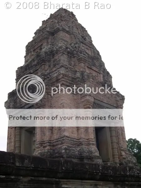
The last temple we saw in the day was Pre Rup, a Hindu temple. To us, this appeared architecturally very similar to Maebon, with same type of stone used in its construction. This temple raised to a good height and we could see lots of tourists at the top waiting to catch a glimpse of sunset from here.

Pre Rup
Pre Rup

It was 30min past 6 in the evening when we came out of Maebon. It had been a long day in the hot sun. We lost lots of body fluid, but fresh coconut water, available at every temple served as our regular replenishments.

Day 2

This day was reserved exclusively to visit Angkor Wat which boasts of world’s largest temple complex measuring 1sq km. Since now we had become fairly familiar with the Angkor area, we decided to hire bicycles for our 2nd day’s tour(3$/day). The tourist crowd at these temples are so much that it becomes difficult to photograph a monument without any human in the frame. So we reached Angkor Wat quite early at 7.30AM.

Apsaras in Angkor Wat
Angkor Wat

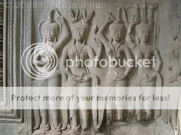
At the entrance of Angkor Wat, we are welcomed by huge sculptures of Lions and Snakes. The temple is surrounded by a moat which needs to be crossed using a bridge of couple of hundred meters length. The temple complex is so huge that we had to walk a few hundred meters to actually reach the temple proper. The temple is built at multiple levels with steep stairs provided to reach a next higher level. The best carvings of Apsaras can be found in this temple. The height of the temple at some places were such that, my camera wasn’t able to get the entire temple wall in a single frame. One can be left wondering about the sheer magnitude of this temple.

Inside Angkor Wat
Angkor Wat

We covered the interiors of the temple first and reached the back of the temple within an hour. The temple seemed to end so quickly and we stood wondering where we had missed the most important part of Angkor Wat, the bas-reliefs (carvings projecting slightly outward from the background). Then some carvings on the exterior walls of the temple caught our attention. It had a depiction of Samudra Manthana, the churning of the ocean, by Devas and Asuras. The bas-reliefs should be covered in the anti-clockwise direction, but we ended up doing it clockwise. With this I had to sometimes cover the entire wall, and re-do it clockwise to get a complete picture.

Churning of Ocean, Bas-reliefs, Angor Wat
Angkor Wat
The exterior walls have depictions of  battle of Ramayana, battle of Kurukshetra, Yama, Heaven and Hell, army of King Suryavarman II. We could identify most of the characters in the carvings here. Angkor Wat was originally a Vishnu temple and we could find many carvings of Garudavahana Vishnu. The battle of Ramayana shows Vanara Sena, Rama, Lakshmana, Hanuman, Vali, Sugreeva etc. The depictions of Heaven and Hell is very interesting with very violent torture scenes like piercing a person with nails. One of the characters easily identifiable from the battle of Kurukshetra is Bheeshma on bed of arrows. We could also find many other Hindu Gods like Ganesha, Indra and Varuna.

Yama, Bas-reliefs, Angkor Wat
Angkor Wat

Bheeshma, Bas-reliefs, Angkor Wat
Angkor Wat

Rama with Hanuman, Bas-reliefs, Angkor Wat
Angkor Wat

Vishnu on Garuda, Bas-reliefs, Angkor Wat
Angkor Wat

We took close to 2 hours to cover all the bas-reliefs and I left the temple with only one feeling – a sense of satisfaction. I felt that my visit to Cambodia has been worth with this visit to the bas-reliefs of Angkor Wat. It was 11.30AM when we came out of the temple complex. We decided to cover Thommanon temple before retiring for the day. We had to bicycle a few km in the hot sun to reach Thommanon. Thommanon is a small Hindu temple dedicated to both Shiva and Vishnu, but we found only the Buddha idols in the Sanctum Sanctorum.
This 12th Century temple is in a good condition compared to others from the same period. However coming from Angkor Wat, the art work here would seem dull as the outer walls of the temple are mostly undecorated.

A carving of Vishnu, Thommanon
Thommanon

Opposite to Thommanon, across the road is the Buddhist temple Chau Say Tevoda, to which we gave a brief visit. However this temple is mostly in ruins and not yet restored fully. We had planned to see only Thommanon, but we couldn’t resist a visit to Ta Keo, which is a few km ahead of Thommanon. Ta Keo is a fairly big Hindu temple dedicated to Shiva, but as with other Hindu temples here, the only remains are usually the dislodged Shiva Linga. Ta Keo is built in several levels and raises to such a height that it is referred to as temple-mountain. Only physically fit can negotiate the steep climb and reach the topmost level of the temple. The construction of this temple is said to be incomplete.

Ta Keo
Ta Keo

Both Vatsa and I were on bicycle after many years, and it was a long tiresome ride back to the Hotel. In the evening we spent a couple of hours shopping in the Old Market Area of Siem Reap. Shopping here is an entertaining experience with most of the shops competing with each other to sell similar goods. Hard bargaining is the way to go and nobody gets offended if we start bargaining from one quarter of the quoted price.

Day 3

On day 3, we left the Hotel at 8AM by taxi(45$) towards Kbal Spean, which is at around 50km from Siem Reap. We passed Banteay Srey on the way, but our driver advised us to visit Kbal Spean first as it involves a climb, which is best done when the sun is still mild. Kbal Spean is Cambodia’s version of our Sahasralinga (Thousand Lingas) present at Sirsi, Karnataka. This place also has lots of Lingas carved on the rocks of the Kbal Spean river. We had to do a 45min walk (a mild climb actually) to reach the actual place where Lingas are located. The place is very scenic located right in the middle of a dense forest.

Shiva Lingas, Reclining Vishnu, Shiva and Uma with Nandi at Kbal Spean
Kbal Spean

The water level in the river was low and hence all the Lingas carved on the rocks were clearly visible to us. In this place, the river mostly flows on a rock bed and most of it has been carved with Lingas. Unusually we could find many Lingas in a single Yoni. I don’t remember seeing this anywhere else.

Apart from Lingas, there are carvings of reclining Vishnu and Shiva with Uma on Nandi. Vishnu and Shiva can be seen on many rocks. There is also a carving of Brahma on a lotus flower. So this is a very unique place in the midst of green settings with the Hindu trinity: Brahma, Vishnu and Maheshwara present side by side. This surely must have been considered a very holy place when these carvings were done (11th to 13th AD).

Banteay Srey
Banteay Srey

On our way back from Kbal Spean, we stopped at Banteay Srey. This 10th AD Hindu temple is constructed form pink sandstone.  The temple stands out from rest of the temples with its intricate carvings. The artwork is very fine and is a pleasure to watch. We can see many references to Hindu Mythology in this temple.

Vali – Sugreeva battle, Banteay Srey
Banteay Srey

Angkor Wat has almost become synonymous with Cambodian temples, but we would have surely missed something had we not seen Kbal Spean and Banteay Srey.

A false door at Banteay Srey
Banteay Srey

On the way back from Banteay Srey, we paid a quick visit to Banteay Samre temple. The weather had turned cloudy and there were no tourists in the temple, which made the temple visit even more special. I would probably remember the quiet moments spent in this temple for many more years to come. The silent stones of this temple had the power to take us back in time.

Banteay Samre
Banteay Samre

As we walked out of Banteay Samre reluctantly, it started to rain as if to signal a climax to our Cambodian temple visit. We were satisfied having seen most of the significant temples in the Siem Reap area, but our driver mentioned that we had missed an important one, Ta Prohm. So unwilling to send us back without a visit to this, he kindly drove us to Ta Prohm, which is near Angkor Thom area. Ta Prohm appeared very similar to Preah Khan but much bigger. However many parts of the temple are still covered by the jungle overgrowth. Most Cambodian temples have been restored with other countries’ aid and Ta Prohm and parts of Angkor Wat have been restored with India’s help.

We were back at the Hotel at 2.30PM and rest of day was spent at the Hotel itself as rain didn’t allow us to venture out. We had been mostly using our own food stuff (MTR food), but for the dinner, we were insisted by the Hotel staff to try out their rice and vegetarian curry which turned out to be very tasty.

Back in Bangkok

We started back to the Cambodia-Thailand border early next morning. It was again a rough ride, but this time it had become even more interesting with rains. But this time, our driver was a bit conservative and turned down our request to drive faster. We were in Aranyaprathet, Thailand by around 12PM and the train to Bangkok was at 2PM. Unwilling to wait, we decided to take a bus to Bangkok and reached Bangkok by evening. We were too tired and ended the day early.

Next day we had some time to spend in Bangkok as our flight was in the night. We took the opportunity to visit the Bangkok palace and a nearby Buddha temple. Also we managed to spend a few hours at the MBK shopping mall.

Bangkok Palace
Bangkok Palace

Reclining Buddha
Reclining Buddha


Muninagara Caves and 21st Century Hoysala Style Temple

September 18, 2007

It was mid June when we decided to inaugurate this year’s trek season by a mild day’s trek to Muninagara. As usual Naren and I were ready and we managed to pull in Ashok also. Muninagara is a tiny village situated at around 30km from Bangalore on the fringes of Bannerghatta National Park. The approach to the village is though from Kanakapura Road. Since we were a short group of just 3, we had decided to take our bikes. So on a cold Saturday morning, we were out on our bikes on Kanakapura Road. First thing on our mind was of course the breakfast. But it was too early in the day to find any hotels open. The couple of hotels which were open weren’t ready to serve anything. Finally we found a Darshini Hotel which served us hot Idlis with burning hot Sambar. We also picked up a few items from a bakery to energize ourselves during the trek.

To reach Muninagara, we have to proceed on Kanakapura Road until Kaggalipura where we need to take a left diversion towards Gulukamale. Once we reach Gulukamale, we need to take a right diversion, pass a couple of villages on the way before reaching Mukkodlu. From Mukkodlu, it is again around 2km to Muninagara.

Muninagara Lake and Hill
Muninagara lake and hill

Since we planned to enter the elephant habitat in Muninagara, we didn’t want to take chances without a proper guide. When we enquired for a guide at Mukkodlu, we were fortunate to find a right person for our job, Munimadayya, who knew everything about the caves and jungles of Muninagara. So with him we travelled further to reach our guide’s hut in Muninagara village. The hut is situated right next to the Muninagara lake. It should be easy to locate Munimadayya’s hut as it is the last hut in the village’s periphery. The lake area is huge but it wasn’t full. It would be a sight to see it filled to its brim. On one side of the lake is the village and on the other side is the forest area followed by a hill. The village is connected to the forest via a well built tank bund. So our first leg of the trek involved crossing the tank bund.

The Cave Entrance
Cave entrance

Munimadayya mentioned that the cultivated fields in the village frequently attract elephants from the Bannerghatta side. He even showed a paddy field which had been grazed to ground by elephants recently. So with an increased hope to spot elephants, we slowly entered the forests. For the starters, we were greeted by a herd of spotted deer. The forest was mainly bushy type without any long trees. After a 45min walk and a mild climb we finally reached the Muninagara Cave or the Siddharagavi. Our head lights were soon out and we entered the cave. The entrance takes us forward for around 10m after which there is a fork and the right fork seems to lead into the interiors of the cave. But we couldn’t get past this fork as there were too many bats. And being disturbed by our headlights, they were almost flying into our heads. We spent a few minutes there with the hope that we could get the bats to the other side so that we could explore the cave a bit more. But the bats stood their ground and we had to retreat.

From then on, we did an uphill walk for an hour to reach the top of the hill. This hill is like a mini table mountain with a large flat surface in the top. Entire Bannerghatta range is visible from this hill top. This hill is part of Bannerghatta National Park and here we were in the National Park without anybody knowing our presence! The place looked like an ideal camping ground for a night. But there is no water available in the top, which can be a problem. Apart from that one should be careful as this is an elephant territory. More than that, I think it is not advisable to spend a night in the Park without permission. After spending some time at the top, we started the descent. Munimadayya took us down from a different route.

From the top
From the top

The next place to visit was the Karadigavi or Bear’s Den which is around 2km from Muninagara situated close to a motorable road. It takes less than 50m of fairly steep ascent (with the last few meters on a rock face) to reach the Bear’s Den. Fortunately bears weren’t at home to welcome us. But there were all signs(like bear’s pug marks and fresh excreta) to show that this home was occupied. And I still think it would be a dangerous proposition to find a bear welcoming you when you have just completed a steep ascent and gasping for breath. The only escape route is to slide down the steep rock face and hope for the best ! So the bottom line is accompany a guide and allow him to reach the cave first.

Bear’s Den
Bear's den

It was around 12.30PM when we said goodbye to Munimadayya and left Muninagara. As we approached Sri Ravishankar’s Art of Living Ashram on Kanakapura Road, we decided to try our luck to get a meal and entered. Within no time we were at lunch hall. The way they provide the lunch and maintain the place is pretty impressive. We were dead hungry by this time and food tasted extremely good. But there was an immediate disappointment when I found my shoes missing from the place where we had left our footwear. I left the place by bidding farewell to my best companion on treks which had accompanied me on so many treks, but was
quite surprised and happy to find my shoes left in a corner. Apparently someone had tried to steal my shoes, probably unable to bear it’s pungent smell had left it behind ! (this is my theory)

This almost turned out to be my shoes’ last photograph!
Shoes

We continued our ride on Kanakapura Road for a few kilometers and took a left diversion into Kumbalagod Main Road. A few kilometers further into this road is the Swanandashrama which boasts a 21st Century Hoysala style temple ! Yes, you read it right, a small temple has been built here in Hoysala style and this is the first time anybody has attempted this amazing feat in 750 years ! The sources say that this work took almost 4 years, thanks to the sculptors Suralu Venkataramana Bhat and his wife of Kadamba Shilpa Shale, Bangalore and his group of 12 sculptors. The temple needed 45 tonnes of soapstone in total. This is a must visit place for anybody interested in Indian temple architecture. It was interesting to see how different a soapstone temple looks when it is just built. Till now we had only seen the old seasoned temples built of soapstone in places like Belur.

Temple Views
Temple view1

Temple view2

Temple view3

We were forced to spend a few extra minutes in the temple by the rain after which time we proceeded towards Bangalore.

All photos are courtesy of Naren.